IMAGES TAKEN NEAR TO
Chandos Street, SHEFFIELD, S10 2PP
Introduction
This page details the photographs taken nearby to Chandos Street, S10 2PP by members of the Geograph project.
The Geograph project started in 2005 with the aim of publishing, organising and preserving representative images for every square kilometre of Great Britain, Ireland and the Isle of Man.

There are currently over 7.5m images from over14,400 individuals and you can help contribute to the project by visiting https://www.geograph.org.uk
Image Map
Images are licensed for reuse under creativecommons.org/licenses/by-sa/2.0
Notes
- Clicking on the map will re-center to the selected point.
- The higher the marker number, the further away the image location is from the centre of the postcode.
Image Listing (186 Images Found)
Images are licensed for reuse under creativecommons.org/licenses/by-sa/2.0
Image
Details
Distance
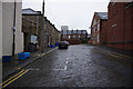
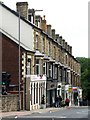
5
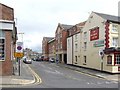
Peel Street, Broomhill
The street once had terraced back-to-back housing on both sides, a telephone exchange and a car showroom. All that's left is the telephone exchange, to the left and the vacant building on the right. The exchange was there in 1925.
Image: © Dave Hitchborne
Taken: 6 Aug 2008
0.03 miles
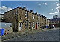
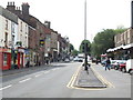
6
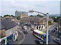
Broomhill crossroads
Crookes Road, Whitam Road, Nile Street and Fulwood Road meet here. The Hallamshire Hospital is visible on the horizon.
Image: © Martin Speck
Taken: 7 Jun 2008
0.03 miles
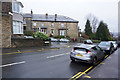
8
Glossop Road, Broomhill
A view towards the city.
Image: © Dave Hitchborne
Taken: 6 Aug 2008
0.03 miles
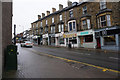
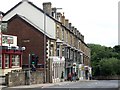
9
Glossop Road, Broomhill
Terraced shops with upper accommodation. You have a shop and live in the flat above. You sell what everyone needs and eventually hire someone to run the shop. You then rent out the flat above and take out a mortgage on another shop and start again. Basically, that's how some chain stores have started.
Image: © Dave Hitchborne
Taken: 6 Aug 2008
0.03 miles
10
Fulwood Road, Broomhill
When I worked at Wade & Ellis, http://www.geograph.org.uk/photo/934074 http://www.geograph.org.uk/photo/983944 during the late ’50s and early ’60s, the shops here were very different. For a start, the shop frontages were, more or less, where the inside edge of the traffic island is. When they were demolished, the South Sea Hotel went with them. The shops included Patrick’s, Haberdashers – Horace Cooke, Watch Repairers – Arthur Davy & Sons Ltd., Pork Butchers and General Grocers – H Naylor, Decorator – Lamppost, Pet Stores – Collins, Bakers – Sine Electric Co. Ltd., Electrical Goods – Ellen Summers, Tobacconists and Shinnah Ltd., Ladies Outfitters.
There was a passageway between the pet stores and the decorators, which led up some steps to a courtyard, houses, what appeared to be redundant stables, a Sports Good Manufacturers and Spooner Road. The courtyard was probably used to offload goods for the shops and beer barrels for the pub, but I never saw any delivery vehicles use it in the six years I worked for Wade & Ellis.
Well, the Cottage Industry was demolished, the South Sea Hotel got rebuilt http://www.geograph.org.uk/photo/1006967 and a new block of shops went up, but instead of using the courtyard for parking, the shops were pushed back and a car park was built on their roofs.
I don’t know why this all came about, nor if anyone thought it was an improvement, but the car park seem to have brought conflict http://www.geograph.org.uk/photo/1007127 and the South Sea Hotel just seems to have been dumped around the corner http://www.geograph.org.uk/photo/1006975.
Ahead, at the traffic lights, http://www.geograph.org.uk/photo/988300 the traffic from Fulwood and Ranmoor, Lodge Moor and Crosspool, split into two lanes. The right-hand lane takes you into the city, by the Hallamshire Hospital. The left-hand lane takes you into the city, by the Western Park Museum, the Children's Hospital and the University buildings.
Image: © Dave Hitchborne
Taken: 6 Aug 2008
0.04 miles