IMAGES TAKEN NEAR TO
Salisbury Road, SHEFFIELD, S10 1WA
Introduction
This page details the photographs taken nearby to Salisbury Road, S10 1WA by members of the Geograph project.
The Geograph project started in 2005 with the aim of publishing, organising and preserving representative images for every square kilometre of Great Britain, Ireland and the Isle of Man.

There are currently over 7.5m images from over14,400 individuals and you can help contribute to the project by visiting https://www.geograph.org.uk
Image Map
Images are licensed for reuse under creativecommons.org/licenses/by-sa/2.0
Notes
- Clicking on the map will re-center to the selected point.
- The higher the marker number, the further away the image location is from the centre of the postcode.
Image Listing (125 Images Found)
Images are licensed for reuse under creativecommons.org/licenses/by-sa/2.0
Image
Details
Distance
1
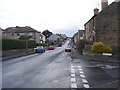
Cross Lane
From its junction with Forres Road.
Image: © Penny Mayes
Taken: 2 Sep 2008
0.06 miles
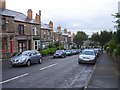
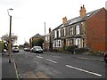
2

Junction of St Thomas Road and Tasker Road
One of a number of Sheffield streets which have worn away to reveal the Victorian cobblestones.
Image: © Jonathan Clitheroe
Taken: 6 Jul 2011
0.06 miles
3
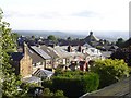
Back of St Thomas Road
Seen from an attic on Forres Road. The roof of Image is prominent on the near skyline.
Image: © Penny Mayes
Taken: 3 Sep 2008
0.08 miles
4
Forres Road, Crookes
The lower part of Forres Road from near its junction with Cross Lane.
Image: © Penny Mayes
Taken: 2 Sep 2008
0.10 miles
6
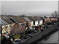
Midfield Road
Looking towards the junction with Suthard Cross Road. The semi-detached houses on the north side of the road were built in the 1970s on an area which shows on the 1853 town plan as Horsfall's Quarry.
Image: © Penny Mayes
Taken: 9 Dec 2011
0.12 miles
7
Crookes, Crookes
Just above the Wesley Hall Methodist Church, is this patch of greenery where in 1935 there once stood a Corn Dealers and a Dentists. This building later sold pikelets and oatcakes, the latter being a particular favourite of mine. Between where the new build is now and the Ball Inn, there used to be terraced houses and shops. In 1965, the shops included a double–fronted shop, which at 155/157 was A Revill’s Grocers Shop and at 163 Bertha Tyler’s Herbalist Shop. During the ‘50s, on occasional Sundays, I used to be sent to the grocers shop because we had run out of something or other. The laws about selling things on a Sunday were very peculiar back then. They would probably allow me to buy a loaf of bread and a packet of cigarettes, but not a bar of soap, or something like that.
Bertha’s Herbalist shop was a pokey little place. To the left, as you walked in, was an old school type bench. Ahead was a counter, a portion of which lifted for the shopkeeper to get through either way. Beyond it was the back room. The wall between and the one to the right was shelved and contained many stone and glass jars of herbs and spices. The counter continued to the right in an L–shape. The air was filled with a mixture of the smell of cinnamon, liquorice, sarsaparilla and Vimto. As a lad, I often went in on a cold winter’s night, for a warm Vimto. The shopkeeper went into the back room to boil the kettle.
Image: © Dave Hitchborne
Taken: 26 Aug 2008
0.12 miles
8
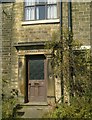
Crookes House
Doorway of Crookes House, Sackville Rd, Crookes.
Image: © Andrew H
Taken: Unknown
0.13 miles
9
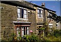
Crookes House
Crookes House, Sackville Rd, Crookes
This house once had large grounds which are all now taken up by the shops and houses which surround it.
Image: © Andrew H
Taken: Unknown
0.13 miles
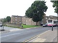
10
Midfield Road
The large building left of centre in this shot is the social club seen in Image
Image: © Penny Mayes
Taken: 12 Dec 2011
0.13 miles