IMAGES TAKEN NEAR TO
Midfield Road, SHEFFIELD, S10 1SW
Introduction
This page details the photographs taken nearby to Midfield Road, S10 1SW by members of the Geograph project.
The Geograph project started in 2005 with the aim of publishing, organising and preserving representative images for every square kilometre of Great Britain, Ireland and the Isle of Man.

There are currently over 7.5m images from over14,400 individuals and you can help contribute to the project by visiting https://www.geograph.org.uk
Image Map
Images are licensed for reuse under creativecommons.org/licenses/by-sa/2.0
Notes
- Clicking on the map will re-center to the selected point.
- The higher the marker number, the further away the image location is from the centre of the postcode.
Image Listing (66 Images Found)
Images are licensed for reuse under creativecommons.org/licenses/by-sa/2.0
Image
Details
Distance
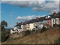
1
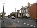
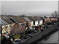
Midfield Road
The large building left of centre in this shot is the social club seen in Image
Image: © Penny Mayes
Taken: 12 Dec 2011
0.01 miles
2
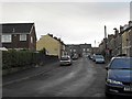
Stannington View Road
Looking up Stannington View Road towards its junctions with Midfield Road and Mulehouse Road.
Image: © Penny Mayes
Taken: 12 Dec 2011
0.03 miles
3
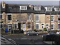
Terraced housing on Stannington View Road
At its junction with Midfield Road.
These houses appear on the 1903 Sheffield town plan.
Image: © Penny Mayes
Taken: 9 Dec 2011
0.03 miles
5
Backs of houses on Stannington View Road
Image: © Neil Theasby
Taken: 6 Oct 2010
0.04 miles
6

Old gas street lamp and telegraph pole in Crookes, Sheffield
Image: © Neil Theasby
Taken: 6 Oct 2010
0.04 miles
7
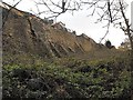
Buttressed garden walls
The houses lie on the north/south part of Stannington View Road. For a view of the front of the houses see http://www.geograph.org.uk/photo/2737504 and for other views of the backs http://www.geograph.org.uk/photo/2737551 and http://www.geograph.org.uk/photo/2098954.
Image: © Penny Mayes
Taken: 12 Dec 2011
0.04 miles
8
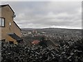
View of Stannington
From Stannington View Road.
The trees in the middle ground show the course of the Rivelin which flows down the valley between Crookes and Stannington. The tower blocks are in Deer Park, Stannington http://www.geograph.org.uk/photo/972372.
Image: © Penny Mayes
Taken: 12 Dec 2011
0.04 miles
9
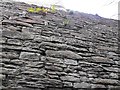
Wall on Long Walk
A closer view of the high wall which supports the house and garden on the left in this photo http://www.geograph.org.uk/photo/2737521.
Image: © Penny Mayes
Taken: 12 Dec 2011
0.05 miles
10
Midfield Road
Looking towards the junction with Suthard Cross Road. The semi-detached houses on the north side of the road were built in the 1970s on an area which shows on the 1853 town plan as Horsfall's Quarry.
Image: © Penny Mayes
Taken: 9 Dec 2011
0.05 miles