IMAGES TAKEN NEAR TO
St. Anthony Road, SHEFFIELD, S10 1SG
Introduction
This page details the photographs taken nearby to St. Anthony Road, S10 1SG by members of the Geograph project.
The Geograph project started in 2005 with the aim of publishing, organising and preserving representative images for every square kilometre of Great Britain, Ireland and the Isle of Man.

There are currently over 7.5m images from over14,400 individuals and you can help contribute to the project by visiting https://www.geograph.org.uk
Image Map
Images are licensed for reuse under creativecommons.org/licenses/by-sa/2.0
Notes
- Clicking on the map will re-center to the selected point.
- The higher the marker number, the further away the image location is from the centre of the postcode.
Image Listing (61 Images Found)
Images are licensed for reuse under creativecommons.org/licenses/by-sa/2.0
Image
Details
Distance
1
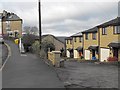
Tinker Lane, near Crookes
Tinker Lane meets Bolehill Lane. Tinker Lane rises up from Bole Hill Road and where they meet is the Walkley to Intake bus terminus.
Image: © Dave Hitchborne
Taken: 26 Aug 2008
0.09 miles
2
Tinker Lane, near Crookes
This shows how steep Tinker Lane really is. I was a bit a weakling until I got a bike. I road up down here times many until I could pedal from bottom to top while still sitting on the saddle. It was a damn good place to sledge down, but a bit of a climb back up.
Also shows three entrances onto the Bolehills; here, just up the road by the cottages and centre distance, via the steps.
Image: © Dave Hitchborne
Taken: 26 Aug 2008
0.09 miles
3
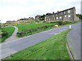
Long Walk
Stannington View Road takes the line of an old path known as Long Walk which ran between the two sandstone quarries, Toft Wood Quarry and Horsfall's Quarry. The western end of the path still exists today and is seen here between the higher building (the last of this row http://www.geograph.org.uk/photo/2737504 ) on the corner of Stannington View Road and the more recently built yellow-brick houses on the right.
Image: © Penny Mayes
Taken: 12 Dec 2011
0.10 miles
4
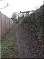
Looking up Long Walk
Towards Stannington View Road.
See Image] for a view from the other direction and further details of this path.
The high wall on the right supports the house on the left in the other photo http://www.geograph.org.uk/photo/2737521.
Image: © Penny Mayes
Taken: 12 Dec 2011
0.10 miles
5
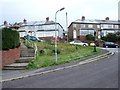
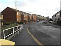
Bolehill Lane, Crookes
Bolehill Lane meets Toftwood Road, to the left and Toftwood Avenue, to the right. If you carry on straight across the junction and walk to the end of Bolehill Lane, before it takes a sharp bend to the right, there is a nice walk down to Clough Fields and several equally nice options to make your way down to the Rivelin Valley. I used to walk down there alone, when my age was in the single figures and there never was any reason to worry about doing so.
There is a very pretty walk, in the valley, that follows the river from Glen Bridge to Rivelin Mill Bridge. My wife and I have walked that and carried on through to Baslow and back.
Image: © Dave Hitchborne
Taken: 26 Aug 2008
0.10 miles
6
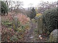
Footpath from the western end of Long Walk
The footpath gives access to St Anthony Road to the east and Clough Fields to the west.
Image: © Penny Mayes
Taken: 12 Dec 2011
0.11 miles
7
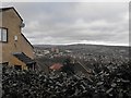
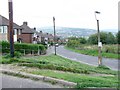
View of Stannington
From Stannington View Road.
The trees in the middle ground show the course of the Rivelin which flows down the valley between Crookes and Stannington. The tower blocks are in Deer Park, Stannington http://www.geograph.org.uk/photo/972372.
Image: © Penny Mayes
Taken: 12 Dec 2011
0.11 miles
8
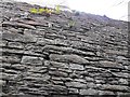
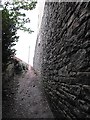
Wall on Long Walk
A closer view of the high wall which supports the house and garden on the left in this photo http://www.geograph.org.uk/photo/2737521.
Image: © Penny Mayes
Taken: 12 Dec 2011
0.11 miles
9
Long Walk
Looking up towards Stannington View Road.
I was surprised to find a small flock of geese in the enclosure behind the hedge on the right.
Image: © Penny Mayes
Taken: 12 Dec 2011
0.11 miles
10
Stannington View Road
This part of Stannington View Road takes the line of an old path known as Long Walk which ran between the two sandstone quarries, Toft Wood Quarry and Horsfall's Quarry.
Image: © Penny Mayes
Taken: 12 Dec 2011
0.12 miles