IMAGES TAKEN NEAR TO
Northfield Avenue, SHEFFIELD, S10 1QN
Introduction
This page details the photographs taken nearby to Northfield Avenue, S10 1QN by members of the Geograph project.
The Geograph project started in 2005 with the aim of publishing, organising and preserving representative images for every square kilometre of Great Britain, Ireland and the Isle of Man.

There are currently over 7.5m images from over14,400 individuals and you can help contribute to the project by visiting https://www.geograph.org.uk
Image Map (Loading...)


Getting Data...Please wait
Leaflet Map data © OpenStreetMap
Images are licensed for reuse under creativecommons.org/licenses/by-sa/2.0
Notes
- Clicking on the map will re-center to the selected point.
- The higher the marker number, the further away the image location is from the centre of the postcode.
Image Listing (141 Images Found)
Images are licensed for reuse under creativecommons.org/licenses/by-sa/2.0
Image
Details
Distance
1
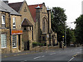
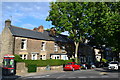
Crookes Road - former St Luke's Methodist Church
Image: © Ivor Hutchinson
Taken: 24 Jul 2004
0.05 miles
2
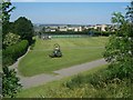
Bole Hill Recreation Ground
Mowing the grass at Bole Hill Recreation Ground. The name Bole Hill is very common. It indicates that the area was once used for metal smelting.
Image: © Martin Speck
Taken: 2 Jul 2009
0.06 miles
3
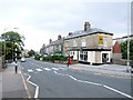
Northfield Road, Crookes
The zebra crossing connects Bradley Street with Northfield Avenue and ultimately the Bolehills recreation ground.
Image: © Dave Hitchborne
Taken: 26 Aug 2008
0.06 miles
4
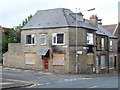
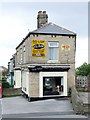
Longfield Road, Crookes
This former shop, on the corner of Northfield Road, was Thomas V Meeson - Confectioner. "Pop", as he was known, seemed to care more for his cats than his customers. They could always be seen sleeping on top of the sweet jars, in the window, or on top of the fridge and the place absolutely stank of cat wee.
It appears that the ground floor, which had been converted into flats, has suffered a fire.
Image: © Dave Hitchborne
Taken: 26 Aug 2008
0.07 miles
5
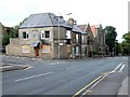
Northfield Road, Crookes
A block of three former shops and the former St Luke's Methodist Church.
The former sweet shop, on the corner of Northfield Road, was Thomas V Meeson - Confectioner. "Pop", as he was known, seemed to care more for his cats than his customers. They could always be seen sleeping on top of the sweet jars, in the window, or on top of the fridge and the place absolutely stank of cat wee.
It appears that the ground floor, which had been converted into flats, has suffered a fire.
Image: © Dave Hitchborne
Taken: 26 Aug 2008
0.07 miles
6
Northfield Road, Crookes
Elle Pelloz - Hair & Beauty Salon. This unusual wedge-shaped shop, whose end faces Bradley Street, takes up two premises, nos. 147-149.
Image: © Dave Hitchborne
Taken: 26 Aug 2008
0.07 miles
9
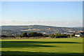
View to Hillsborough, from Bolehill Recreation Ground, Northfield Avenue, Crookes, Sheffield
Image: © Terry Robinson
Taken: 16 Aug 2013
0.08 miles
10
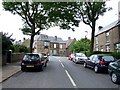
Western Road, Crookes
A glimpse of the former shops and Methodist Church, on Northfield Road http://www.geograph.org.uk/photo/2187489
Image: © Dave Hitchborne
Taken: 26 Aug 2008
0.08 miles