IMAGES TAKEN NEAR TO
Brighton Terrace Road, SHEFFIELD, S10 1NU
Introduction
This page details the photographs taken nearby to Brighton Terrace Road, S10 1NU by members of the Geograph project.
The Geograph project started in 2005 with the aim of publishing, organising and preserving representative images for every square kilometre of Great Britain, Ireland and the Isle of Man.

There are currently over 7.5m images from over14,400 individuals and you can help contribute to the project by visiting https://www.geograph.org.uk
Image Map
Images are licensed for reuse under creativecommons.org/licenses/by-sa/2.0
Notes
- Clicking on the map will re-center to the selected point.
- The higher the marker number, the further away the image location is from the centre of the postcode.
Image Listing (139 Images Found)
Images are licensed for reuse under creativecommons.org/licenses/by-sa/2.0
Image
Details
Distance
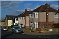
2
Western Road, Crookes
This house with the unusual projection above the bay windows stands on the corner of Springvale Road and Western Road.
The old road sign above the far right bay window http://www.geograph.org.uk/photo/1197992
Image: © Dave Hitchborne
Taken: 26 Aug 2008
0.06 miles
3
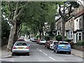
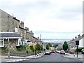
Western Road, Crookes
The road is cut in two here by Springvale Road and we're looking up towards the shops on Northfield Road.
The trees were here back in the '50s, at least.
Image: © Dave Hitchborne
Taken: 26 Aug 2008
0.06 miles
4
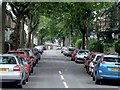
Western Road, Crookes
This tree-lined road leads up to Northfield Road and the shops.
The sign, top left, leads us to St Timothy's Parish Church on Bradley Street.
Image: © Dave Hitchborne
Taken: 26 Aug 2008
0.06 miles
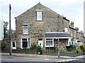
5
Springvale Road, Crookes
An old road sign lives on.
Image: © Dave Hitchborne
Taken: 26 Aug 2008
0.06 miles
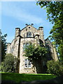
6
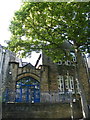
Sunday School Building and Door Detail, Crookes Congregational Church (Former), Springvale Road, Norton, Sheffield
For more information about the Church and additional views ... see ...
Image
Image
Image
Image
Image
Image
Image
Image
Image
Image
Image: © Terry Robinson
Taken: 3 Sep 2012
0.06 miles
7
Springvale Road, Crookes
This view looks way down across Penistone Road, the River Don and on towards Attercliffe and Tinsley. Older residents on this road will have been able to see, in the distance, steelworks disappear and the Don Valley Stadium and Sheffield Arena spring up. The background noise of steam hammers, and the singing in the church http://www.geograph.org.uk/photo/1189869 has long gone, but the sound of children going to and from school, lives on http://www.geograph.org.uk/photo/1198069
Image: © Dave Hitchborne
Taken: 26 Aug 2008
0.07 miles
8
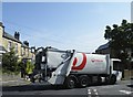
Veolia Day at the Springvale Road and Western Road Junction, Norton, Sheffield
Image: © Terry Robinson
Taken: 3 Sep 2012
0.07 miles
9
Crookes Congregational Church (Former), Springvale Road, Norton, Sheffield - 5
For more information about the Church and additional views ... see ...
Image
Image
Image
Image
Image
Image
Image
Image
Image
Image
Image: © Terry Robinson
Taken: 3 Sep 2012
0.07 miles
10
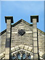
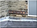
Date Stone Detail, Crookes Congregational Church (Former), Springvale Road, Norton, Sheffield
For more information about the Church and additional views ... see ...
Image
Image
Image
Image
Image
Image
Image
Image
Image
Image
Image: © Terry Robinson
Taken: 3 Sep 2012
0.07 miles