IMAGES TAKEN NEAR TO
Bosworth Street, SHEFFIELD, S10 1HB
Introduction
This page details the photographs taken nearby to Bosworth Street, S10 1HB by members of the Geograph project.
The Geograph project started in 2005 with the aim of publishing, organising and preserving representative images for every square kilometre of Great Britain, Ireland and the Isle of Man.

There are currently over 7.5m images from over14,400 individuals and you can help contribute to the project by visiting https://www.geograph.org.uk
Image Map (Loading...)


Getting Data...Please wait
Leaflet Map data © OpenStreetMap
Images are licensed for reuse under creativecommons.org/licenses/by-sa/2.0
Notes
- Clicking on the map will re-center to the selected point.
- The higher the marker number, the further away the image location is from the centre of the postcode.
Image Listing (206 Images Found)
Images are licensed for reuse under creativecommons.org/licenses/by-sa/2.0
Image
Details
Distance
1
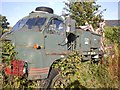
Breakdown Truck
Abandoned Breakdown truck behind Twigg Brothers Garage, Toyne Street, Crookes.
Image: © Andrew H
Taken: Unknown
0.06 miles
2
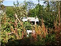
Breakdown Truck
Another abandoned breakdown truck behind Twigg Brothers Garage, Toyne Street, Crookes.
Image: © Andrew H
Taken: Unknown
0.06 miles
3
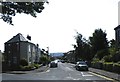
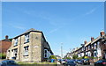
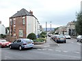
Cobden View Road and Springvale Road Junction, Norton, Sheffield - 3
Springvale Road runs across the picture, Cobden View Road runs away from the photo position.
See also ...
Image
Image
Image: © Terry Robinson
Taken: 3 Sep 2012
0.07 miles
6
Cobden View Road and Springvale Road Junction, Norton, Sheffield - 2
Springvale Road runs across the picture, Cobden View Road runs up the picture.
For other views of the junction ... see ...
Image
Image
See also ...
Image
Image: © Terry Robinson
Taken: 3 Sep 2012
0.08 miles
7
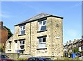
Cobden View Mount, Cobden View Road, Norton, Sheffield
The date stone shows this mansion to have been built in 1898 ... the Black and Blue Wheelie Bins are dated a little later.
See also ...
Image
Image: © Terry Robinson
Taken: 3 Sep 2012
0.08 miles
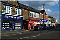
8
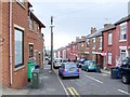
Toyne Street, Crookes
While still at school, I did the occasional part-time leaflet drop. They were handed over by the thousand and I had to shove one through every letter box until they were gone. Toyne Street, with its roadside doorways, was always my first port of call.
This was also an alternative way to Western Road School, instead of going via Springvale Road.
Image: © Dave Hitchborne
Taken: 26 Oct 2008
0.08 miles
9
Cobden View Road, Crookes
Looking from across the other side of Springvale Road, the view leads you to the skyline of Norton and the tiny silhouette of the water tower http://www.geograph.org.uk/photo/226088
Image: © Dave Hitchborne
Taken: 26 Aug 2008
0.08 miles
10
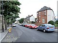
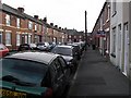
Springvale Road, Crookes
To the left, not quite in view, is the former Crookes Congregational Church. The red brick building across the road, stands at the corner of Cobden View Road. The next junction, at the shop just in view down Springvale Road, is with Western Road.
Image: © Dave Hitchborne
Taken: 26 Aug 2008
0.08 miles