IMAGES TAKEN NEAR TO
Ongar Road, ROMFORD, RM4 1UJ
Introduction
This page details the photographs taken nearby to Ongar Road, RM4 1UJ by members of the Geograph project.
The Geograph project started in 2005 with the aim of publishing, organising and preserving representative images for every square kilometre of Great Britain, Ireland and the Isle of Man.

There are currently over 7.5m images from over14,400 individuals and you can help contribute to the project by visiting https://www.geograph.org.uk
Image Map
Images are licensed for reuse under creativecommons.org/licenses/by-sa/2.0
Notes
- Clicking on the map will re-center to the selected point.
- The higher the marker number, the further away the image location is from the centre of the postcode.
Image Listing (6 Images Found)
Images are licensed for reuse under creativecommons.org/licenses/by-sa/2.0
Image
Details
Distance
1
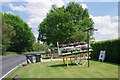
Flower Cart at Oak Farm
Potted plants by the A113
Image: © Glyn Baker
Taken: 23 May 2019
0.04 miles
2
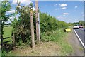
Footpath PROW 194_1
The path runs for 325m to the junction with PROW 194_19 on the south bank of the River Roding.
Image: © Glyn Baker
Taken: 23 May 2019
0.11 miles
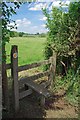
5
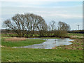
River Roding
The river was high after a lot of rain earlier in the week.
Image: © Robin Webster
Taken: 14 Apr 2013
0.18 miles
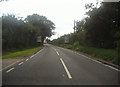
6
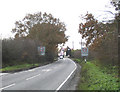
Entrance to Abridge Village
Looking west along Ongar Road (the A113) towards Abridge
Image: © John Winfield
Taken: 14 Dec 2005
0.25 miles