IMAGES TAKEN NEAR TO
Abridge, ROMFORD, RM4 1TU
Introduction
This page details the photographs taken nearby to RM4 1TU by members of the Geograph project.
The Geograph project started in 2005 with the aim of publishing, organising and preserving representative images for every square kilometre of Great Britain, Ireland and the Isle of Man.

There are currently over 7.5m images from over14,400 individuals and you can help contribute to the project by visiting https://www.geograph.org.uk
Image Map
Images are licensed for reuse under creativecommons.org/licenses/by-sa/2.0
Notes
- Clicking on the map will re-center to the selected point.
- The higher the marker number, the further away the image location is from the centre of the postcode.
Image Listing (5 Images Found)
Images are licensed for reuse under creativecommons.org/licenses/by-sa/2.0
Image
Details
Distance
1
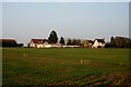
Hydes Farm
View of Hydes Farm from the Public Footpath
Image: © Lee Holmes
Taken: 15 Mar 2012
0.03 miles
2

Roman Driveway
This farm drive follows the course of a Roman road according to the OS map.
Image: © Glyn Baker
Taken: 23 May 2010
0.08 miles
3
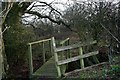
Hydes Lane
Hydes Lane a Public Footpath towards Hydes Farm
Image: © Lee Holmes
Taken: 15 Mar 2012
0.17 miles
4
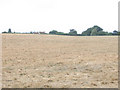
Route of Roman Road
The Landranger map shows the route of a Roman Road crossing the field below Hydes Farm, roughly in the direction of the photo.
Image: © Stephen Craven
Taken: 12 Aug 2006
0.20 miles
5
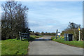
Private road to Hyde Farm
Also a public footpath to Theydon Garnon.
Image: © Robin Webster
Taken: 14 Apr 2013
0.25 miles