IMAGES TAKEN NEAR TO
Albyns Lane, ROMFORD, RM4 1RS
Introduction
This page details the photographs taken nearby to Albyns Lane, RM4 1RS by members of the Geograph project.
The Geograph project started in 2005 with the aim of publishing, organising and preserving representative images for every square kilometre of Great Britain, Ireland and the Isle of Man.

There are currently over 7.5m images from over14,400 individuals and you can help contribute to the project by visiting https://www.geograph.org.uk
Image Map
Images are licensed for reuse under creativecommons.org/licenses/by-sa/2.0
Notes
- Clicking on the map will re-center to the selected point.
- The higher the marker number, the further away the image location is from the centre of the postcode.
Image Listing (3 Images Found)
Images are licensed for reuse under creativecommons.org/licenses/by-sa/2.0
Image
Details
Distance
1
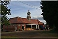
Albyns Coach House
From the public footpath view the former 18th Century Coach-house of Albyns Manor, now used as farm building.
Image: © Lee Holmes
Taken: 26 Aug 2012
0.11 miles
2
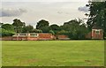
Old Albyns Manor Wall
There was formerly a very fine manor house at Albyns, most of which dated from the early 17th century. It incorporated parts of a smaller house which was probably built by the Cely family in the middle of the 16th century. The building was fully surveyed in 1920 by the Royal Commission on Historical Monuments. A few years later the American owner removed most of the elaborate 17th-century fittings and transported them to the United States. The subsequent owner demolished the north side of the house and rebuilt the facade further back. In 1945 a V2 Rocket did come down close to Albyns Manor doing enough damage to the house that it was demolished as a direct result in the early 1950s.
Image: © Lee Holmes
Taken: 26 Aug 2012
0.13 miles