IMAGES TAKEN NEAR TO
Hoe Lane, ROMFORD, RM4 1NP
Introduction
This page details the photographs taken nearby to Hoe Lane, RM4 1NP by members of the Geograph project.
The Geograph project started in 2005 with the aim of publishing, organising and preserving representative images for every square kilometre of Great Britain, Ireland and the Isle of Man.

There are currently over 7.5m images from over14,400 individuals and you can help contribute to the project by visiting https://www.geograph.org.uk
Image Map
Images are licensed for reuse under creativecommons.org/licenses/by-sa/2.0
Notes
- Clicking on the map will re-center to the selected point.
- The higher the marker number, the further away the image location is from the centre of the postcode.
Image Listing (6 Images Found)
Images are licensed for reuse under creativecommons.org/licenses/by-sa/2.0
Image
Details
Distance
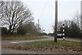
2
Fingerpost, between Abridge and Lambourne End
Situated at junction of Hoe Lane and New Road
Image: © John Winfield
Taken: 14 Dec 2005
0.15 miles
4
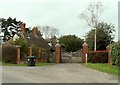
The entrance to Bishop's Hall from New Road
The picture shows the lodge, which is common to find at the gate of a large hall.
Image: © Robert Edwards
Taken: 17 Mar 2008
0.18 miles
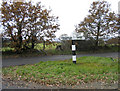
5
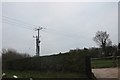
Electricity pole by New Road, Lambourne End
Image: © David Howard
Taken: 5 Jan 2019
0.21 miles
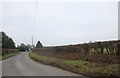
6
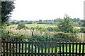
View from The Camelot car park
Looking towards Epping Forest in the far distance.
Image: © Trevor Harris
Taken: 18 Sep 2013
0.25 miles