IMAGES TAKEN NEAR TO
The Paddocks, ROMFORD, RM4 1HG
Introduction
This page details the photographs taken nearby to The Paddocks, RM4 1HG by members of the Geograph project.
The Geograph project started in 2005 with the aim of publishing, organising and preserving representative images for every square kilometre of Great Britain, Ireland and the Isle of Man.

There are currently over 7.5m images from over14,400 individuals and you can help contribute to the project by visiting https://www.geograph.org.uk
Image Map
Images are licensed for reuse under creativecommons.org/licenses/by-sa/2.0
Notes
- Clicking on the map will re-center to the selected point.
- The higher the marker number, the further away the image location is from the centre of the postcode.
Image Listing (7 Images Found)
Images are licensed for reuse under creativecommons.org/licenses/by-sa/2.0
Image
Details
Distance
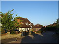
4
Houses on Murthering Lane near Stapleford Abbotts
Image: © David Howard
Taken: 21 Nov 2021
0.08 miles
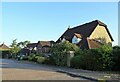
5
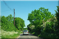
Murthering Lane
Murthering sounds quite nice, but the only definition I can find for murther is that it is an obsolete word for murder.
Image: © Robin Webster
Taken: 26 May 2012
0.09 miles
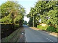
6
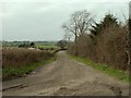
The road to Olives Farm and Tysea Hill Farm
The house in the distance belongs to Olives Farm. The road is also a public footpath.
Image: © Robert Edwards
Taken: 17 Mar 2008
0.12 miles
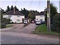
7
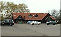
The Clubhouse at Stapleford Abbotts Golf Club
Image: © Robert Edwards
Taken: 19 Mar 2008
0.25 miles