IMAGES TAKEN NEAR TO
Hounds Grove, RM4 1FA
Introduction
This page details the photographs taken nearby to Hounds Grove, RM4 1FA by members of the Geograph project.
The Geograph project started in 2005 with the aim of publishing, organising and preserving representative images for every square kilometre of Great Britain, Ireland and the Isle of Man.

There are currently over 7.5m images from over14,400 individuals and you can help contribute to the project by visiting https://www.geograph.org.uk
Image Map
Images are licensed for reuse under creativecommons.org/licenses/by-sa/2.0
Notes
- Clicking on the map will re-center to the selected point.
- The higher the marker number, the further away the image location is from the centre of the postcode.
Image Listing (8 Images Found)
Images are licensed for reuse under creativecommons.org/licenses/by-sa/2.0
Image
Details
Distance
2
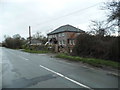
At the boundary of London
The camera is in Essex, looking into the London Borough of Havering.
Image: © Robin Webster
Taken: 30 Jun 2012
0.15 miles
3
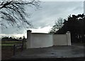
Wall at the entrance to Orange Tree Kennels
Image: © David Howard
Taken: 5 Mar 2017
0.15 miles
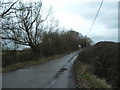
4
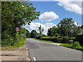
Paternoster Row at the junction of Church Road
Image: © David Howard
Taken: 5 Mar 2017
0.16 miles
5
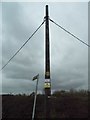
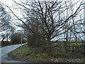
Telephone pole on Church Road, Noak Hill
Image: © David Howard
Taken: 5 Mar 2017
0.18 miles
7
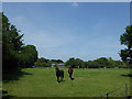
Horses in a field
This is seen from Paternoster Row at Noak Hill and just yards from the London LOOP.
Image: © Marathon
Taken: 14 Jun 2017
0.20 miles
8
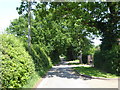
Paternoster Row, Noak Hill
This is Paternoster Row at Noak Hill, just yards from the London LOOP.
Image: © Marathon
Taken: 14 Jun 2017
0.21 miles