IMAGES TAKEN NEAR TO
Theydon Meadows, RM4 1EY
Introduction
This page details the photographs taken nearby to Theydon Meadows, RM4 1EY by members of the Geograph project.
The Geograph project started in 2005 with the aim of publishing, organising and preserving representative images for every square kilometre of Great Britain, Ireland and the Isle of Man.

There are currently over 7.5m images from over14,400 individuals and you can help contribute to the project by visiting https://www.geograph.org.uk
Image Map
Images are licensed for reuse under creativecommons.org/licenses/by-sa/2.0
Notes
- Clicking on the map will re-center to the selected point.
- The higher the marker number, the further away the image location is from the centre of the postcode.
Image Listing (6 Images Found)
Images are licensed for reuse under creativecommons.org/licenses/by-sa/2.0
Image
Details
Distance
1
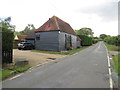
Epping Lane, near Abridge
Epping Lane passing through Essex countryside. The black-painted building appears to be a converted barn.
Image: © Malc McDonald
Taken: 17 Aug 2019
0.09 miles
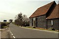
3

Hedge by Hobbs Cross Road, Theydon Garnon
Image: © David Howard
Taken: 23 Jan 2022
0.15 miles
4
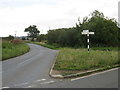
Hobbs Cross Road, near Abridge
Hobbs Cross Road, at its junction with Epping Lane. A traditional signpost provides directions.
Image: © Malc McDonald
Taken: 17 Aug 2019
0.16 miles
5
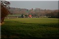
Hobbs Cross Cottage
View from Hydes Lane Public Footpath of Hobbs Cottage and Abridge Golf Course and Bush Grove in the background.
Image: © Lee Holmes
Taken: 15 Mar 2012
0.21 miles
6

Field gate near Brook Farm,Abridge
A misty morning in the Roding Valley,looking southwest from a field near to Brook Farm.
Image: © Ian Dalgliesh
Taken: 13 Nov 2008
0.22 miles