IMAGES TAKEN NEAR TO
Oak Hill Road, ROMFORD, RM4 1EH
Introduction
This page details the photographs taken nearby to Oak Hill Road, RM4 1EH by members of the Geograph project.
The Geograph project started in 2005 with the aim of publishing, organising and preserving representative images for every square kilometre of Great Britain, Ireland and the Isle of Man.

There are currently over 7.5m images from over14,400 individuals and you can help contribute to the project by visiting https://www.geograph.org.uk
Image Map
Images are licensed for reuse under creativecommons.org/licenses/by-sa/2.0
Notes
- Clicking on the map will re-center to the selected point.
- The higher the marker number, the further away the image location is from the centre of the postcode.
Image Listing (5 Images Found)
Images are licensed for reuse under creativecommons.org/licenses/by-sa/2.0
Image
Details
Distance
1
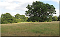
Tree in field near Twinoaks Farm, Stapleford Abbotts
Image: © Roger Jones
Taken: 22 Jul 2020
0.12 miles
2
The Royal Oak Public House Stapleford Abbotts
Image: © Phil Gaskin
Taken: 5 Jun 2011
0.13 miles
3
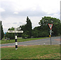
Signpost, Bournebridge Lane, Stapleford Abbotts, Essex
One of the few remaining wooden signposts in the area that still retain the black and white banding.
Image: © John Winfield
Taken: 4 Jul 2005
0.21 miles
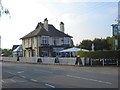
4
Royal Oak, Stapleford Abbotts
The Royal Oak pub in the village of Stapleford Abbotts.
Image: © Malc McDonald
Taken: 25 May 2013
0.23 miles
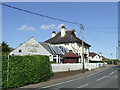
5
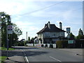
Oak Hill Road, Stapleford Abbotts
Oak Hill Road passing through the village of Stapleford Abbotts. On the right is the Royal Oak pub.
Although the village is outside the Greater London boundary, the bus stop is provided by London's transport authority, Transport for London, as the main local bus route here is a Transport for London service which crosses the boundary into Essex.
Image: © Malc McDonald
Taken: 25 May 2013
0.24 miles