IMAGES TAKEN NEAR TO
Gutteridge Lane, ROMFORD, RM4 1EG
Introduction
This page details the photographs taken nearby to Gutteridge Lane, RM4 1EG by members of the Geograph project.
The Geograph project started in 2005 with the aim of publishing, organising and preserving representative images for every square kilometre of Great Britain, Ireland and the Isle of Man.

There are currently over 7.5m images from over14,400 individuals and you can help contribute to the project by visiting https://www.geograph.org.uk
Image Map
Images are licensed for reuse under creativecommons.org/licenses/by-sa/2.0
Notes
- Clicking on the map will re-center to the selected point.
- The higher the marker number, the further away the image location is from the centre of the postcode.
Image Listing (11 Images Found)
Images are licensed for reuse under creativecommons.org/licenses/by-sa/2.0
Image
Details
Distance
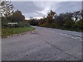
1
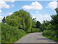
Gutteridge Lane - former route of B175
The old road through route was slightly straightened beyond this point between the wars, and then this loop was completely bypassed after WWII.
Image: © Robin Webster
Taken: 30 Jun 2012
0.03 miles
2
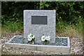
Memorial to P.C. George William Gutteridge
At the age of 38 PC Gutteridge was shot dead while on duty and questioning two men he stopped in the early hours of September 27th 1927.
The stone was unveiled by the Essex Chief Constable, Captain A J Unett, in 1928. The bullets and Webley revolver used to kill George Gutteridge are in the Essex Police Museum, whilst other exhibits relating to Browne and Kennedy are in the Black Museum at Scotland Yard.
The memorial stone is situated close to where George Gutteridge was murdered on the Romford to Chipping Ongar Road. The alignment of the road has been changed since 1927 and a short stretch of it has been renamed Gutteridge Lane.
The memorial stone was set at Gutteridge Lane, on the Romford to Chipping Ongar road, midway between the Royal Oak and The Rabbits public houses. His grave is in Warley Cemetery.
Frederick Browne and William Henry “Pat” Kennedy were tried and found guilty of murdering Police Constable George W. Gutteridge and on the 31sy May 1928, they were hanged simultaneously, Browne at Pentonville and Kennedy at Wandsworth
Image: © Tony Peacock
Taken: 31 Jul 2013
0.06 miles
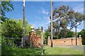
4
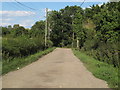
Footpath on track near Mitchell's Farm, Stapleford Abbotts
Image: © Roger Jones
Taken: 22 Jul 2020
0.09 miles
5
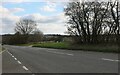
Gutteridge Lane at the junction of Stapleford Road
Image: © David Howard
Taken: 21 Nov 2021
0.12 miles
6
Footpath 206_22 To Bournebridge Lane
This is the gate to Willow Hall. PROW 206_22 is 1093m long.
Image: © Glyn Baker
Taken: 23 May 2019
0.14 miles
7
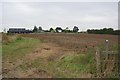
Footpath to Grove House
The right of way crosses the ploughed field
Image: © Glyn Baker
Taken: 16 Oct 2011
0.14 miles
8
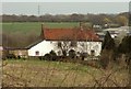
The farmhouse at Stapleford Hall Farm
Image: © Robert Edwards
Taken: 17 Mar 2008
0.16 miles
9
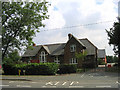
Village School, Stapleford Abbotts, Essex
Image: © John Winfield
Taken: 2 Aug 2005
0.16 miles
10
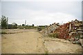
Remains of High House Farm
Nothing but rubble is left now of this farm yard.
Image: © Glyn Baker
Taken: 16 Oct 2011
0.17 miles