IMAGES TAKEN NEAR TO
Alderwood Drive, ROMFORD, RM4 1DD
Introduction
This page details the photographs taken nearby to Alderwood Drive, RM4 1DD by members of the Geograph project.
The Geograph project started in 2005 with the aim of publishing, organising and preserving representative images for every square kilometre of Great Britain, Ireland and the Isle of Man.

There are currently over 7.5m images from over14,400 individuals and you can help contribute to the project by visiting https://www.geograph.org.uk
Image Map
Images are licensed for reuse under creativecommons.org/licenses/by-sa/2.0
Notes
- Clicking on the map will re-center to the selected point.
- The higher the marker number, the further away the image location is from the centre of the postcode.
Image Listing (44 Images Found)
Images are licensed for reuse under creativecommons.org/licenses/by-sa/2.0
Image
Details
Distance
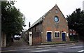
4
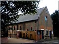
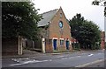
Holy Trinity church, Abridge
Built in 1836.
Image: © Bikeboy
Taken: 13 Sep 2014
0.17 miles
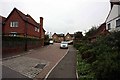
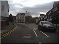
5
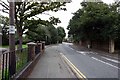
Road past Holy Trinity Church, Abridge, Essex
Image: © John Salmon
Taken: 13 Sep 2008
0.17 miles
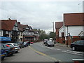
10
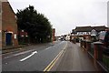
Road past Holy Trinity Church, Abridge, Essex
Image: © John Salmon
Taken: 13 Sep 2008
0.19 miles