IMAGES TAKEN NEAR TO
Ongar Road, ROMFORD, RM4 1AA
Introduction
This page details the photographs taken nearby to Ongar Road, RM4 1AA by members of the Geograph project.
The Geograph project started in 2005 with the aim of publishing, organising and preserving representative images for every square kilometre of Great Britain, Ireland and the Isle of Man.

There are currently over 7.5m images from over14,400 individuals and you can help contribute to the project by visiting https://www.geograph.org.uk
Image Map
Images are licensed for reuse under creativecommons.org/licenses/by-sa/2.0
Notes
- Clicking on the map will re-center to the selected point.
- The higher the marker number, the further away the image location is from the centre of the postcode.
Image Listing (6 Images Found)
Images are licensed for reuse under creativecommons.org/licenses/by-sa/2.0
Image
Details
Distance
1
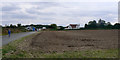
Patch Park Farm and buildings
These buildings comprise a private house on the right, and various semi-industrial/agricultural buildings to the left. There are public footpaths through the site.
Image: © John Rostron
Taken: 6 Sep 2009
0.01 miles
2
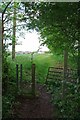
Footpath to Priors Farm
This path PROW 194-4 runs 761m from The Elms in Church Lane to the A113 via Priors Farm. It is part of the Three Forests Way https://www.ldwa.org.uk/ldp/members/show_path.php?path_name=Three+Forests+Way
Image: © Glyn Baker
Taken: 23 May 2019
0.09 miles
3
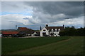
Pryors Farm
View from the Public Footpath
Image: © Lee Holmes
Taken: 15 Apr 2012
0.14 miles
4

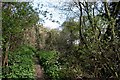
Lambourne Place
Public Footpath runs down the side of Lambourne Place looking into the back garden which has a underground bunker.
Image: © Lee Holmes
Taken: 15 Apr 2012
0.21 miles
5
Foxburrow Wood, Lambourne
Abridge woods April 2012
Image: © Lee Holmes
Taken: 15 Apr 2012
0.23 miles
6
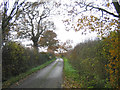
A country lane, Abridge
Church Lane is on south side of Ongar Road and leads to Lambourne Church
Image: © John Winfield
Taken: 14 Dec 2005
0.24 miles