IMAGES TAKEN NEAR TO
London Road, GRAYS, RM20 4AR
Introduction
This page details the photographs taken nearby to London Road, RM20 4AR by members of the Geograph project.
The Geograph project started in 2005 with the aim of publishing, organising and preserving representative images for every square kilometre of Great Britain, Ireland and the Isle of Man.

There are currently over 7.5m images from over14,400 individuals and you can help contribute to the project by visiting https://www.geograph.org.uk
Image Map (Loading...)


Getting Data...Please wait
Leaflet Map data © OpenStreetMap
Images are licensed for reuse under creativecommons.org/licenses/by-sa/2.0
Notes
- Clicking on the map will re-center to the selected point.
- The higher the marker number, the further away the image location is from the centre of the postcode.
Image Listing (13 Images Found)
Images are licensed for reuse under creativecommons.org/licenses/by-sa/2.0
Image
Details
Distance
1
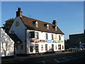
The Ship Public House, West Thurrock
Grade II listed public house on the London Road.
See http://www.britishlistedbuildings.co.uk/en-119748-ship-public-house- for more details about this listed pub.
Image: © David Anstiss
Taken: 7 Nov 2012
0.01 miles
2
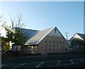
St Clement's Church, West Thurrock
On London Road.
Image: © David Anstiss
Taken: 7 Nov 2012
0.02 miles
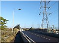
4
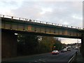
Railway bridge over the London Road, South Stifford
The A126 London Road leads from Purfleet towards Grays.
It passes under the railway between Chafford Hundred and Grays.
Image: © David Anstiss
Taken: 7 Nov 2012
0.12 miles
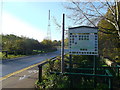
6
Stoneness Roundabout
Stoneness Road leads from various industrial estates (on the West Thurrock Marshes), it then becomes the A126 West Thurrock Way (heading towards Lakeside).
It crosses the London Road (west Thurrock) heading left towards Purfleet or right towards South Stifford.
Image: © David Anstiss
Taken: 7 Nov 2012
0.14 miles
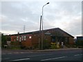
7
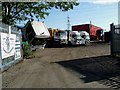
Trucks to Mend
This is a small HGV truck repair and sales depot in Sandy Lane West Thurrock
Image: © Glyn Baker
Taken: 26 Aug 2005
0.20 miles
8
St Clement's Walk, West Thurrock
On the right a narrow public path leads beside an old church boundary wall towards a disused church, now part of a nature reserve.
The road on the right is used by workers at the nearby Proctor and Gamble Works.
Image: © David Anstiss
Taken: 7 Nov 2012
0.20 miles
9
Stonehouses Road, West Thurrock
This road leads from the road through The West Thurrock Industrial Estates.
It passes over the railway between Grays and Purfleet.
Image: © David Anstiss
Taken: 7 Nov 2012
0.20 miles
10
Cowdray Hall, West Thurrock
On London Road.
Used for various uses, including exercise classes.
Image: © David Anstiss
Taken: 7 Nov 2012
0.21 miles