IMAGES TAKEN NEAR TO
Credo Way, GRAYS, RM20 3JE
Introduction
This page details the photographs taken nearby to Credo Way, RM20 3JE by members of the Geograph project.
The Geograph project started in 2005 with the aim of publishing, organising and preserving representative images for every square kilometre of Great Britain, Ireland and the Isle of Man.

There are currently over 7.5m images from over14,400 individuals and you can help contribute to the project by visiting https://www.geograph.org.uk
Image Map
Images are licensed for reuse under creativecommons.org/licenses/by-sa/2.0
Notes
- Clicking on the map will re-center to the selected point.
- The higher the marker number, the further away the image location is from the centre of the postcode.
Image Listing (20 Images Found)
Images are licensed for reuse under creativecommons.org/licenses/by-sa/2.0
Image
Details
Distance
1
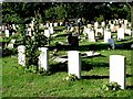
Some Corner of a Foreign Field
This is a view across West Thurrock Cemetery. The three graves in the foreground are those of Sappers Tola, Scovil, O’Lary & Gardner, all of the Canadian Railway Troops. The first three died between 13th and 21 October 1918 a matter of days before the end of the war. There are other graves from the same regiment at the same time dotted around the graveyard. To be buried in Thurrock the action in which they were involved would have probably happened in the first two weeks of October, they survived long enough to be evacuated, could it be that influenza finished what the war had started? Sorry for the bleached out inscriptions (another go sometime with evening light called for). 2010 UPDATE the War and Medical records of Sapper FWB (Francis William Becham) Andrews (who is also buried in West Thurrock) show he was originally from Herefordshire but emigrated to Canada in about 1912. He joined the Canadian Railway Troops in July, 1918 and arrived in England in September, 1918. His medical records indicated he started having very high fevers (most likely Spanish flu) in early October and he died on October 25, 1918. He mostly likely was not the only one since this flu was so contagious. Thanks to Gordon Thompson of Canada for the extra info.
Image: © Glyn Baker
Taken: 26 Aug 2005
0.05 miles
2
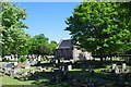
West Thurrock Cemetery Chapel
There are some interesting WW1 graves in this cemetery see Image
Image: © Glyn Baker
Taken: 5 May 2020
0.07 miles
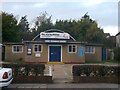
4
Cowdray Hall, West Thurrock
On London Road.
Used for various uses, including exercise classes.
Image: © David Anstiss
Taken: 7 Nov 2012
0.07 miles
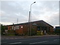
5

Trucks to Mend
This is a small HGV truck repair and sales depot in Sandy Lane West Thurrock
Image: © Glyn Baker
Taken: 26 Aug 2005
0.08 miles
6

Pylon and Footpath 16
Behind the fence on the left is a former chalk pit that is now an industrial estate. To the right is West Thurrock Cemetery.
Image: © Glyn Baker
Taken: 5 May 2020
0.12 miles

8

Stoneness Roundabout
Stoneness Road leads from various industrial estates (on the West Thurrock Marshes), it then becomes the A126 West Thurrock Way (heading towards Lakeside).
It crosses the London Road (west Thurrock) heading left towards Purfleet or right towards South Stifford.
Image: © David Anstiss
Taken: 7 Nov 2012
0.15 miles
9
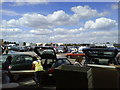
Loading Area and Car Park, Ikea Thurrock
Ikea is a large furniture supermarket. After you buy your furniture you bring your car round from the car park to this loading area where you attempt to get it all into the vehicle. Usually the product comes in a flat pack for easier transportation. Most cars used in the UK are hatchbacks with a fold down rear seat which makes the job a lot easier.
Image: © Danny P Robinson
Taken: 29 Jul 2007
0.16 miles
10

Loading Area, Ikea Thurrock
After you have paid for the furniture you bring the flat packs to this loading area and then bring the car or van round from the car park. This photo was taken at around 10.15 pm as the shop was beginning to close up.
Image: © Danny P Robinson
Taken: 18 Jul 2007
0.16 miles