IMAGES TAKEN NEAR TO
Oliver Road, GRAYS, RM20 3AS
Introduction
This page details the photographs taken nearby to Oliver Road, RM20 3AS by members of the Geograph project.
The Geograph project started in 2005 with the aim of publishing, organising and preserving representative images for every square kilometre of Great Britain, Ireland and the Isle of Man.

There are currently over 7.5m images from over14,400 individuals and you can help contribute to the project by visiting https://www.geograph.org.uk
Image Map
Images are licensed for reuse under creativecommons.org/licenses/by-sa/2.0
Notes
- Clicking on the map will re-center to the selected point.
- The higher the marker number, the further away the image location is from the centre of the postcode.
Image Listing (17 Images Found)
Images are licensed for reuse under creativecommons.org/licenses/by-sa/2.0
Image
Details
Distance
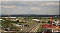
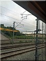
3
Looking across derelict land to an industrial unit, West Thurrock
Image: © N Chadwick
Taken: 18 Jun 2011
0.14 miles
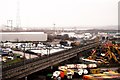
6
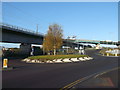
Roundabout on St Clements Way
St Clements Way, leads from the various industrial parks on the West Thurrock Marshes towards London Road (West Thurrock).
On the left is the High Speed 1 Railway, carrying the Channel Tunnel Rail Link to London.
The later both pass under the A282 road leading towards the Queen Elizabeth Road Bridge (Dartford Bridge).
Image: © David Anstiss
Taken: 7 Nov 2012
0.18 miles
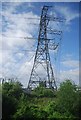
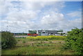
8
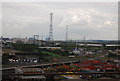
Looking north across the West Thurrock Marshes
Image: © N Chadwick
Taken: 8 Nov 2009
0.20 miles
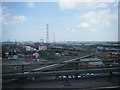
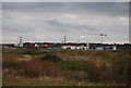
10
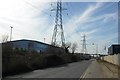
Oliver Road, West Thurrock
The Queen Elizabeth Bridge can be seen ahead in the distance.
Image: © Trevor Harris
Taken: 10 Mar 2015
0.21 miles