IMAGES TAKEN NEAR TO
London Road, PURFLEET-ON-THAMES, RM19 1QP
Introduction
This page details the photographs taken nearby to London Road, RM19 1QP by members of the Geograph project.
The Geograph project started in 2005 with the aim of publishing, organising and preserving representative images for every square kilometre of Great Britain, Ireland and the Isle of Man.

There are currently over 7.5m images from over14,400 individuals and you can help contribute to the project by visiting https://www.geograph.org.uk
Image Map
Images are licensed for reuse under creativecommons.org/licenses/by-sa/2.0
Notes
- Clicking on the map will re-center to the selected point.
- The higher the marker number, the further away the image location is from the centre of the postcode.
Image Listing (100 Images Found)
Images are licensed for reuse under creativecommons.org/licenses/by-sa/2.0
Image
Details
Distance

2
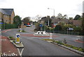
Roundabout on the A1090 (London Rd), Purfleet
Image: © N Chadwick
Taken: 8 Nov 2009
0.03 miles
3
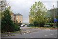
Harrison's Wharf, Purfleet
A new housing development on the site of an old wharf
Image: © N Chadwick
Taken: 8 Nov 2009
0.03 miles
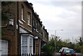
7
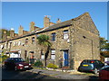
Botany Terrace, Purfleet
As seen from London Road (Purfleet).
Image: © David Anstiss
Taken: 7 Nov 2012
0.06 miles
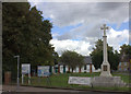
8
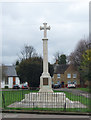
War Memorial, St Stephen's Church, Purfleet
Image: © N Chadwick
Taken: 8 Nov 2009
0.06 miles
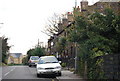
9
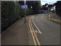
Cycle Lane
A very short cycle lane in Purfleet
Image: © Sophie
Taken: 5 Aug 2024
0.06 miles
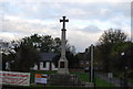
10
War memorial and St Stephen's church, Purfleet
Image: © Robert Eva
Taken: 9 Sep 2017
0.07 miles