IMAGES TAKEN NEAR TO
Stephenson Avenue, TILBURY, RM18 8XD
Introduction
This page details the photographs taken nearby to Stephenson Avenue, RM18 8XD by members of the Geograph project.
The Geograph project started in 2005 with the aim of publishing, organising and preserving representative images for every square kilometre of Great Britain, Ireland and the Isle of Man.

There are currently over 7.5m images from over14,400 individuals and you can help contribute to the project by visiting https://www.geograph.org.uk
Image Map
Images are licensed for reuse under creativecommons.org/licenses/by-sa/2.0
Notes
- Clicking on the map will re-center to the selected point.
- The higher the marker number, the further away the image location is from the centre of the postcode.
Image Listing (16 Images Found)
Images are licensed for reuse under creativecommons.org/licenses/by-sa/2.0
Image
Details
Distance
3
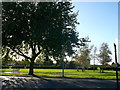
Tree beside Feenan Highway, Tilbury
In the background is King George's Field.
Image: © David Anstiss
Taken: 16 Oct 2012
0.11 miles

5

Feenan Highway, Tilbury
This road leads up towards Chadwell St Mary.
As seen from Anchor Fields Park.
Image: © David Anstiss
Taken: 16 Oct 2012
0.17 miles
6

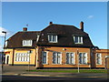
'The Anchor' public house in Tilbury
Image: © Robert Edwards
Taken: 26 Oct 2009
0.17 miles
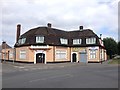
8
The Anchor Public house, Tilbury
On Brennan Road.
Image: © David Anstiss
Taken: 16 Oct 2012
0.19 miles
10

Trees near Parkside Avenue
This clump of trees is in a triangular green space near Anchor Fields Park.
Image: © David Anstiss
Taken: 16 Oct 2012
0.20 miles