1
Holford Farm
Image: © John Matthews
Taken: 25 Nov 2009
0.03 miles
2
Estate boundary marker, Blue Anchor Lane, West Tilbury
Estate boundary marker for the land owned by the Sir John Cass's Foundation. Milestone Society ID no EX_THURR02em
Wikipedia says:
"The Common Fields
"Unique to this part of Essex, West Tilbury still has a large expanse of unenclosed (unhedged) land known as 'Great Common.' This was one of the three medieval areas of strip field, on which the manorial farmers worked their individual copyhold ribbons of ground. It lies backing the village Green and public house. There was another comparable area off Low Street Lane, known as the 'Little Common', where similarly the individual strips (called 'dayworks' here in the medieval period) were marked out by posts or other distinguishing features. The last of these posts – of cast iron – were re-erected in 1868 and bear the name of Sir John Cass, whose charity school at Aldgate owned an estate and strip plots here.
Agriculture
"Unusually for south Essex, West Tilbury continued to operate some open field farming well into the 19th century. Although they were in the open field, individual holdings were freehold. There were occasional disputes as to the location of these holdings. In due course, the two institutional land owners – the Sir John Cass Foundation and the town of Henley on Thames – erected markers to define their holdings."
Image: © Paul Jones
Taken: 22 Mar 2022
0.06 miles
3
Estate boundary marker, Blue Angel Lane, West Tilbury
Estate boundary marker for the land owned by the Sir John Cass's Foundation. Milestone Society ref no EX_THURR01em
Wikipedia says:
"The Common Fields
Unique to this part of Essex, West Tilbury still has a large expanse of unenclosed (unhedged) land known as 'Great Common.' This was one of the three medieval areas of strip field, on which the manorial farmers worked their individual copyhold ribbons of ground. It lies backing the village Green and public house. There was another comparable area off Low Street Lane, known as the 'Little Common', where similarly the individual strips (called 'dayworks' here in the medieval period) were marked out by posts or other distinguishing features. The last of these posts – of cast iron – were re-erected in 1868 and bear the name of Sir John Cass, whose charity school at Aldgate owned an estate and strip plots here.
Agriculture
Unusually for south Essex, West Tilbury continued to operate some open field farming well into the 19th century. Although they were in the open field, individual holdings were freehold. There were occasional disputes as to the location of these holdings. In due course, the two institutional land owners – the Sir John Cass Foundation and the town of Henley on Thames – erected markers to define their holdings."
Image: © Paul Jones
Taken: 22 Mar 2022
0.10 miles
4
West Tilbury Village Green
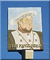
This is the village green at West Tilbury. The GR is for the King's Head pub sign.
Image: © Glyn Baker
Taken: 2 Mar 2006
0.17 miles
5
The King's Head, West Tilbury
Grade II Listed public house facing the village green.
See http://www.britishlistedbuildings.co.uk/en-119667-kings-head-public-house- for more details about the pub.
Image: © David Anstiss
Taken: 16 Oct 2012
0.17 miles
6
The Green, West Tilbury (2011)
The 'King's Head' seen here closed in around 2015 and the building is now a private residence. The stocks seen in the foreground were still there in 2022.
Image: © David Kemp
Taken: 4 Dec 2011
0.17 miles
7
Post House, West Tilbury
Grade II listed building on Rectory Road within the village.
See http://www.britishlistedbuildings.co.uk/en-119792-post-house- for more details about the building.
Image: © David Anstiss
Taken: 16 Oct 2012
0.18 miles
8
The King's Head, Pub Sign, West Tilbury
Outside the pub on the village Green.
Image: © David Anstiss
Taken: 16 Oct 2012
0.18 miles
9
The Green, West Tilbury (2022)
The building on the right is the former 'King's Head' public house which closed in around 2015.
Image: © David Kemp
Taken: 28 Jan 2022
0.18 miles
10
Manor Farm, West Tilbury
Grade II listed building within the village.
As seen from the Green.
See http://www.britishlistedbuildings.co.uk/en-119665-manor-farmhouse- for more details about the building.
Image: © David Anstiss
Taken: 16 Oct 2012
0.18 miles


