IMAGES TAKEN NEAR TO
Gun Hill, TILBURY, RM18 8TH
Introduction
This page details the photographs taken nearby to Gun Hill, RM18 8TH by members of the Geograph project.
The Geograph project started in 2005 with the aim of publishing, organising and preserving representative images for every square kilometre of Great Britain, Ireland and the Isle of Man.

There are currently over 7.5m images from over14,400 individuals and you can help contribute to the project by visiting https://www.geograph.org.uk
Image Map
Images are licensed for reuse under creativecommons.org/licenses/by-sa/2.0
Notes
- Clicking on the map will re-center to the selected point.
- The higher the marker number, the further away the image location is from the centre of the postcode.
Image Listing (17 Images Found)
Images are licensed for reuse under creativecommons.org/licenses/by-sa/2.0
Image
Details
Distance
1
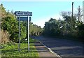
Gun Hill, West Tilbury
This road leads downhill towards Fort Road.
Image: © David Anstiss
Taken: 16 Oct 2012
0.03 miles
2
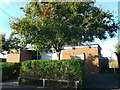
West Tilbury Village Hall
On Rectory Road, near the old Primary School.
Image: © David Anstiss
Taken: 16 Oct 2012
0.13 miles
3
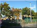
Former West Tilbury Primary School
Disused building along Rectory Road.
Image: © David Anstiss
Taken: 16 Oct 2012
0.13 miles
4
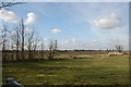
View North West of West Tilbury
Looking towards Chadwell St Mary.
Image: © Trevor Harris
Taken: 26 Feb 2012
0.13 miles
5

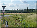
Track to Gunhill Farm
Taken from Fort Road
Image: © Trevor Harris
Taken: 26 Feb 2012
0.15 miles
6
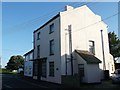
Post House, West Tilbury
Grade II listed building on Rectory Road within the village.
See http://www.britishlistedbuildings.co.uk/en-119792-post-house- for more details about the building.
Image: © David Anstiss
Taken: 16 Oct 2012
0.15 miles
7
View towards Gunhill Farm
The early 19th century house grade II listed house is coyly hiding in the trees at the foot of the hill.
Image: © Robin Webster
Taken: 10 Jul 2011
0.16 miles
8
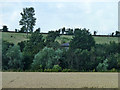
Gunhill Farm
The early 19th century house grade II listed house is coyly hiding in the trees and seemingly a bit overwhelmed by them.
Image: © Robin Webster
Taken: 10 Jul 2011
0.16 miles
9
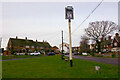
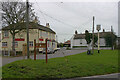
Former public house sign, West Tilbury
Although the 'King's Head' closed in around 2015, its sign remains on the village green.
Image: © David Kemp
Taken: 28 Jan 2022
0.18 miles
10
The Green, West Tilbury (2011)
The 'King's Head' seen here closed in around 2015 and the building is now a private residence. The stocks seen in the foreground were still there in 2022.
Image: © David Kemp
Taken: 4 Dec 2011
0.19 miles