IMAGES TAKEN NEAR TO
Coronation Avenue, TILBURY, RM18 8TE
Introduction
This page details the photographs taken nearby to Coronation Avenue, RM18 8TE by members of the Geograph project.
The Geograph project started in 2005 with the aim of publishing, organising and preserving representative images for every square kilometre of Great Britain, Ireland and the Isle of Man.

There are currently over 7.5m images from over14,400 individuals and you can help contribute to the project by visiting https://www.geograph.org.uk
Image Map (Loading...)


Getting Data...Please wait
Leaflet Map data © OpenStreetMap
Images are licensed for reuse under creativecommons.org/licenses/by-sa/2.0
Notes
- Clicking on the map will re-center to the selected point.
- The higher the marker number, the further away the image location is from the centre of the postcode.
Image Listing (4 Images Found)
Images are licensed for reuse under creativecommons.org/licenses/by-sa/2.0
Image
Details
Distance
1
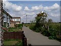
The Edge of Town
An unusual feature of the pedestrianised streets in the area is they are named after rivers with no title such as street road or drive. This is the edge of “Welland”
Image: © Glyn Baker
Taken: 13 Aug 2005
0.15 miles
2
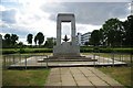
Green Space & Bata War Memorial
This is the Image it is unusual in that it is an exclusively second world war memorial for the workers of the Image you can see in the background.
Image: © Glyn Baker
Taken: 14 May 2011
0.24 miles
3
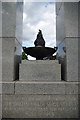
Bata War Memorial
The dedication on the memorial you can see in Image
Image: © Glyn Baker
Taken: 14 May 2011
0.24 miles
4
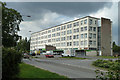
Stanford House, East Tilbury
Originally the Bata Hotel.
Image: © Robin Webster
Taken: 10 Jul 2011
0.25 miles