IMAGES TAKEN NEAR TO
Thomas Bata Avenue, TILBURY, RM18 8SH
Introduction
This page details the photographs taken nearby to Thomas Bata Avenue, RM18 8SH by members of the Geograph project.
The Geograph project started in 2005 with the aim of publishing, organising and preserving representative images for every square kilometre of Great Britain, Ireland and the Isle of Man.

There are currently over 7.5m images from over14,400 individuals and you can help contribute to the project by visiting https://www.geograph.org.uk
Image Map
Images are licensed for reuse under creativecommons.org/licenses/by-sa/2.0
Notes
- Clicking on the map will re-center to the selected point.
- The higher the marker number, the further away the image location is from the centre of the postcode.
Image Listing (39 Images Found)
Images are licensed for reuse under creativecommons.org/licenses/by-sa/2.0
Image
Details
Distance
1
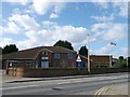
East Tilbury Scout Hut
Large building on Princess Margaret Road within the town.
In the gold alcove on the 2nd floor, is a model of a scout!
Image: © David Anstiss
Taken: 16 Oct 2012
0.15 miles
2
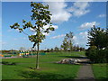
Path in Gobions Park
This small council managed park is near the housing estates of East Tilbury.
It got a development grant of £50,000 to 2009.
Image: © David Anstiss
Taken: 16 Oct 2012
0.15 miles
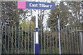
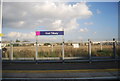
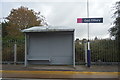
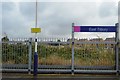
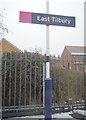
10
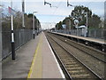
East Tilbury railway station, Essex
Opened in 1936 by the London Midland & Scottish Railway on the line from London Fenchurch Street to Shoeburyness via the Tilbury loop. View north east towards Stanford-le-Hope and Shoeburyness.
Image: © Nigel Thompson
Taken: 24 Feb 2012
0.16 miles