IMAGES TAKEN NEAR TO
Low Street Lane, TILBURY, RM18 8RA
Introduction
This page details the photographs taken nearby to Low Street Lane, RM18 8RA by members of the Geograph project.
The Geograph project started in 2005 with the aim of publishing, organising and preserving representative images for every square kilometre of Great Britain, Ireland and the Isle of Man.

There are currently over 7.5m images from over14,400 individuals and you can help contribute to the project by visiting https://www.geograph.org.uk
Image Map (Loading...)


Getting Data...Please wait
Leaflet Map data © OpenStreetMap
Images are licensed for reuse under creativecommons.org/licenses/by-sa/2.0
Notes
- Clicking on the map will re-center to the selected point.
- The higher the marker number, the further away the image location is from the centre of the postcode.
Image Listing (21 Images Found)
Images are licensed for reuse under creativecommons.org/licenses/by-sa/2.0
Image
Details
Distance
1
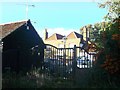
Polwicks, East Tilbury
Grade II listed house on Station Road.
See http://www.britishlistedbuildings.co.uk/en-119642-polwicks- for more details.
Image: © David Anstiss
Taken: 16 Oct 2012
0.06 miles
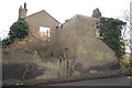
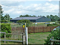
2
Church Road, Low Street
The ruin of Condovers is on the right.
Image: © Robin Webster
Taken: 10 Jul 2011
0.07 miles
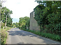
4
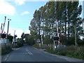
Corner at Low Street
Near Walnut Tree Farm. Taken from Church Road which, to the east, becomes Station Road.
Image: © Trevor Harris
Taken: 26 Feb 2012
0.09 miles
6
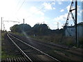
Railway to Tilbury
As seen from Image
Part of a straight section through East Tilbury Marshes.
Image: © David Anstiss
Taken: 16 Oct 2012
0.12 miles
8
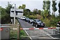
Level Crossing on Station Road
Station Road leads from East Tilbury towards Low Street.
It passes over the railway between Tilbury and East Tilbury.
Image: © David Anstiss
Taken: 16 Oct 2012
0.12 miles
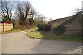
10
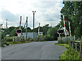
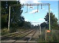
Level crossing, Low Street
The station, closed in 1967, was on the right.
Image: © Robin Webster
Taken: 10 Jul 2011
0.13 miles