IMAGES TAKEN NEAR TO
Princess Margaret Road, TILBURY, RM18 8PA
Introduction
This page details the photographs taken nearby to Princess Margaret Road, RM18 8PA by members of the Geograph project.
The Geograph project started in 2005 with the aim of publishing, organising and preserving representative images for every square kilometre of Great Britain, Ireland and the Isle of Man.

There are currently over 7.5m images from over14,400 individuals and you can help contribute to the project by visiting https://www.geograph.org.uk
Image Map
Images are licensed for reuse under creativecommons.org/licenses/by-sa/2.0
Notes
- Clicking on the map will re-center to the selected point.
- The higher the marker number, the further away the image location is from the centre of the postcode.
Image Listing (3 Images Found)
Images are licensed for reuse under creativecommons.org/licenses/by-sa/2.0
Image
Details
Distance
1

Telecommunications towers, East Tilbury
There used to be a gravel pit here, so this domed hill must be land fill.
Image: © Robin Webster
Taken: 10 Jul 2011
0.10 miles
2

Love Lane, East Tilbury
One way towards Low Street.
Image: © Robin Webster
Taken: 10 Jul 2011
0.21 miles
3
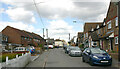
Princess Margaret Road, East Tilbury Village
Local signage distinguishes between East Tilbury and East Tilbury Village. Whereas the former includes the station and former Bata factory, the latter is where the parish church and Coalhouse Fort are to be found. Indeed the two parts are separated by open fields.
Image: © David Kemp
Taken: 5 May 2021
0.25 miles