IMAGES TAKEN NEAR TO
Princess Margaret Road, TILBURY, RM18 8NX
Introduction
This page details the photographs taken nearby to Princess Margaret Road, RM18 8NX by members of the Geograph project.
The Geograph project started in 2005 with the aim of publishing, organising and preserving representative images for every square kilometre of Great Britain, Ireland and the Isle of Man.

There are currently over 7.5m images from over14,400 individuals and you can help contribute to the project by visiting https://www.geograph.org.uk
Image Map
Images are licensed for reuse under creativecommons.org/licenses/by-sa/2.0
Notes
- Clicking on the map will re-center to the selected point.
- The higher the marker number, the further away the image location is from the centre of the postcode.
Image Listing (21 Images Found)
Images are licensed for reuse under creativecommons.org/licenses/by-sa/2.0
Image
Details
Distance
1
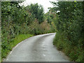
Love Lane, East Tilbury
One way towards Low Street.
Image: © Robin Webster
Taken: 10 Jul 2011
0.12 miles
2
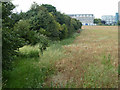
Hedgerow and field north of Love Lane
Image: © Robin Webster
Taken: 10 Jul 2011
0.12 miles
3

East Tilbury Marshes
Taken from Princess Margaret Road. Site of former sand and gravel workings.
Image: © Trevor Harris
Taken: 16 Feb 2018
0.20 miles
4

The Bata shoe factory, East Tilbury
The factory - with its water tower - is something of a landmark along this stretch of the river. I've often seen it from the Kent bank, but on this occasion I was passing a little closer, aboard PS Waverley. Nonetheless, this remains a long-range shot, from a distance of more than 2km.
For a closer look, I recommend Stephen Richards' contribution: http://www.geograph.org.uk/photo/4687396
From the evidence of my own photograph, I'd say the more easterly block has been refurbished since 2015.
Image: © Stefan Czapski
Taken: 6 Oct 2017
0.21 miles
5
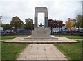
East Tilbury: Bata Shoe Company War Memorial
Please see Glyn Baker's Image] for a view in the opposite direction, and his Image] for a view of the inscription. Since Tomáš Baťa only founded his shoe production factory here in 1932, the Memorial only commemorates World War II deaths. Since Glyn's 2011 photograph the railings around the memorial plinth have been removed.
Image: © Nigel Cox
Taken: 20 Oct 2016
0.21 miles
6
British Bata Shoe Company war memorial
Image: © Robin Webster
Taken: 10 Jul 2011
0.21 miles
7
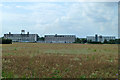
Former Bata shoe factory, East Tilbury
An early 1930s advanced design by Czech architects, the left and right buildings are grade II listed, but not the centre one for some reason.
Image: © Robin Webster
Taken: 10 Jul 2011
0.22 miles
8

Former Bata factory, East Tilbury
These are two southernmost parts of the former factory complex. The block on the right appears to be in the process of redevelopment but its left-hand counterpart still has an air of dereliction (though it still carries the Bata logo). The factory finally closed in 2005.
Image: © David Kemp
Taken: 5 May 2021
0.22 miles
9

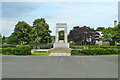
Bata War Memorial
The dedication on the memorial you can see in Image
Image: © Glyn Baker
Taken: 14 May 2011
0.22 miles
10
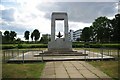
Green Space & Bata War Memorial
This is the Image it is unusual in that it is an exclusively second world war memorial for the workers of the Image you can see in the background.
Image: © Glyn Baker
Taken: 14 May 2011
0.22 miles