IMAGES TAKEN NEAR TO
Sandhurst Road, TILBURY, RM18 8DH
Introduction
This page details the photographs taken nearby to Sandhurst Road, RM18 8DH by members of the Geograph project.
The Geograph project started in 2005 with the aim of publishing, organising and preserving representative images for every square kilometre of Great Britain, Ireland and the Isle of Man.

There are currently over 7.5m images from over14,400 individuals and you can help contribute to the project by visiting https://www.geograph.org.uk
Image Map
Images are licensed for reuse under creativecommons.org/licenses/by-sa/2.0
Notes
- Clicking on the map will re-center to the selected point.
- The higher the marker number, the further away the image location is from the centre of the postcode.
Image Listing (17 Images Found)
Images are licensed for reuse under creativecommons.org/licenses/by-sa/2.0
Image
Details
Distance
1

Tilbury Loop Line
Looking towards London, or more specifically here, towards where Tilbury Riverside station used to be. The original main line of the London, Tilbury and Southend railway, opened over this section in 1854.
Image: © Robin Webster
Taken: 10 Jul 2011
0.02 miles
2

Welcome to Tilbury
It's actually near the middle of Tilbury close to the river but it's mainly referring to the dock area.
Image: © David Howard
Taken: 22 Oct 2023
0.06 miles


8
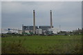
Fort Road, Tilbury
Ahead is the bridge over the railway; to the right is the entrance to Tilbury Power Station.
Image: © Trevor Harris
Taken: 26 Feb 2012
0.11 miles
9

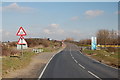
Fort Road towards Tilbury Fort
This road leads from West Tilbury towards the fort and the docks.
It passes over the railway between Tilbury and West Tilbury.
Image: © David Anstiss
Taken: 16 Oct 2012
0.13 miles
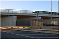
10

Fort Road, Tilbury
Ramping up to bridge the railway. The bridge replaced a level crossing, and was built in conjunction with Tilbury power station, to the cost of the CEGB, I imagine. For a period both were open, the general public being obliged to use the level crossing. After the wrangling over responsibilities and money was over, the level crossing was closed.
Image: © Robin Webster
Taken: 10 Jul 2011
0.13 miles