IMAGES TAKEN NEAR TO
Wellington Road, TILBURY, RM18 7PR
Introduction
This page details the photographs taken nearby to Wellington Road, RM18 7PR by members of the Geograph project.
The Geograph project started in 2005 with the aim of publishing, organising and preserving representative images for every square kilometre of Great Britain, Ireland and the Isle of Man.

There are currently over 7.5m images from over14,400 individuals and you can help contribute to the project by visiting https://www.geograph.org.uk
Image Map
Images are licensed for reuse under creativecommons.org/licenses/by-sa/2.0
Notes
- Clicking on the map will re-center to the selected point.
- The higher the marker number, the further away the image location is from the centre of the postcode.
Image Listing (84 Images Found)
Images are licensed for reuse under creativecommons.org/licenses/by-sa/2.0
Image
Details
Distance
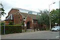
1
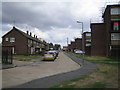
Tilbury: Wellington Road
Post-war housing development.
Image: © Nigel Cox
Taken: 11 Aug 2006
0.03 miles
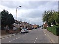
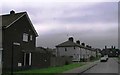
2
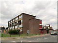
Housing blocks on Montreal Road
An older generation of housing than that on Hume Avenue nearby Image
Image: © Stephen Craven
Taken: 10 Aug 2013
0.03 miles
3
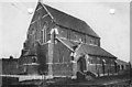
St Johns Church. Dock Rd.Tilbury. Essex Pre 1920
A very brief history - it was built in 1902. At the end of WWI, the roof was removed as it was causing the Church to subside. The vicarage was built some time in the 1920s, and is still used by the current Vicar (Father Tim Codling). In the 1960s, a Church hall was added (as per the second picture), by the then Vicar (Father Tony Hickey).
Apparently, the altar was originally at the other end of the Church, with a triptych painting donated by P&O (then connected with the Docks) after two of their sailors drowned. The altar was later moved to the other end (though I don't know when), and the painting moved to the Lady's chapel. In 2002, a new stained glass window was put in. Scanned Photo Supplied and permission to place on Flickr and Geograph given by Dan Blows [Blowski]. For which I am eternally grateful.
Image: © Dan Blow [BIOWSKI]
Taken: Unknown
0.04 miles
4
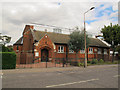
Church of St John the Baptist, Tilbury Docks
Judging by the wording on the notice board, this Anglican parish church is in the Anglo-Catholic tradition.
Image: © Stephen Craven
Taken: 10 Aug 2013
0.04 miles
5
Tilbury Docks church
The Church of St. John the Baptist was opened in 1904 with a considerably higher and more ornate roof. Because of foundation problems, the heavy upper part of the church and roof were removed some years later. A replacement lighter roof was built below the level of the clerestory seen here. A further much later modification was to raise the roof a little to enable the clerestory. The various states of the church may be seen at https://www.tilburyandchadwellmemories.org.uk/content/places/churches_and_cemeteries_in_tilbury_and_chadwell/st_john_the_baptist_dock_road_tilbury
Image: © Robin Webster
Taken: 10 Jul 2011
0.04 miles
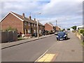
9
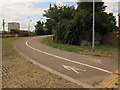
Path to the Hairpin Bridge
A segregated pedestrian/cycle path leading from Dock Road.
Image: © Stephen Craven
Taken: 10 Aug 2013
0.07 miles
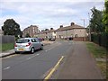
10
Junction of Auckland Close and Sydney Road in Tilbury
Correction to date
Image: © Clint Mann
Taken: 15 Dec 2001
0.09 miles