IMAGES TAKEN NEAR TO
Dock Road, TILBURY, RM18 7EQ
Introduction
This page details the photographs taken nearby to Dock Road, RM18 7EQ by members of the Geograph project.
The Geograph project started in 2005 with the aim of publishing, organising and preserving representative images for every square kilometre of Great Britain, Ireland and the Isle of Man.

There are currently over 7.5m images from over14,400 individuals and you can help contribute to the project by visiting https://www.geograph.org.uk
Image Map
Images are licensed for reuse under creativecommons.org/licenses/by-sa/2.0
Notes
- Clicking on the map will re-center to the selected point.
- The higher the marker number, the further away the image location is from the centre of the postcode.
Image Listing (11 Images Found)
Images are licensed for reuse under creativecommons.org/licenses/by-sa/2.0
Image
Details
Distance
1
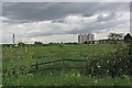
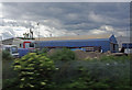
The Edge of Tilbury
There is a very sharp line between town and country in Tilbury
Image: © Glyn Baker
Taken: 14 May 2011
0.02 miles
2
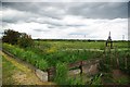
A Tilbury Dike
Less than five minutes walk from Tilbury Town Station the vista is rural
Image: © Glyn Baker
Taken: 14 May 2011
0.06 miles
5

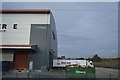
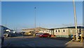
Drive-through McDonald's, Tilbury
Positioned at one end of the large Asda supermarket car park.
Image: © Robin Webster
Taken: 10 Jul 2011
0.15 miles
7
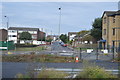
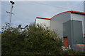
Russell Rd, Dock Rd junction (mini-roundabout)
Image: © N Chadwick
Taken: 8 Oct 2016
0.21 miles
9
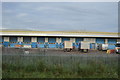
A Warehouse In Tilbury Dock
Taken from a C2C Tilbury Line Train approaching Tilbury Town Station
Image: © Glyn Baker
Taken: 14 May 2011
0.22 miles
10
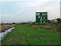
Field Drain Near The A1089
This drain is parallel to the A1089 approach to Tilbury.
Image: © Glyn Baker
Taken: 23 Aug 2005
0.23 miles