IMAGES TAKEN NEAR TO
Winchelsea Road, TILBURY, RM18 7EE
Introduction
This page details the photographs taken nearby to Winchelsea Road, RM18 7EE by members of the Geograph project.
The Geograph project started in 2005 with the aim of publishing, organising and preserving representative images for every square kilometre of Great Britain, Ireland and the Isle of Man.

There are currently over 7.5m images from over14,400 individuals and you can help contribute to the project by visiting https://www.geograph.org.uk
Image Map
Images are licensed for reuse under creativecommons.org/licenses/by-sa/2.0
Notes
- Clicking on the map will re-center to the selected point.
- The higher the marker number, the further away the image location is from the centre of the postcode.
Image Listing (2 Images Found)
Images are licensed for reuse under creativecommons.org/licenses/by-sa/2.0
Image
Details
Distance
1
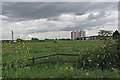
The Edge of Tilbury
There is a very sharp line between town and country in Tilbury
Image: © Glyn Baker
Taken: 14 May 2011
0.18 miles
2
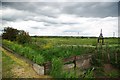
A Tilbury Dike
Less than five minutes walk from Tilbury Town Station the vista is rural
Image: © Glyn Baker
Taken: 14 May 2011
0.20 miles