IMAGES TAKEN NEAR TO
West Street, GRAYS, RM17 6XP
Introduction
This page details the photographs taken nearby to West Street, RM17 6XP by members of the Geograph project.
The Geograph project started in 2005 with the aim of publishing, organising and preserving representative images for every square kilometre of Great Britain, Ireland and the Isle of Man.

There are currently over 7.5m images from over14,400 individuals and you can help contribute to the project by visiting https://www.geograph.org.uk
Image Map
Images are licensed for reuse under creativecommons.org/licenses/by-sa/2.0
Notes
- Clicking on the map will re-center to the selected point.
- The higher the marker number, the further away the image location is from the centre of the postcode.
Image Listing (137 Images Found)
Images are licensed for reuse under creativecommons.org/licenses/by-sa/2.0
Image
Details
Distance
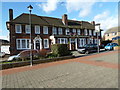
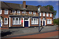
5
The White Hart, Argent St
An excellent town centre pub, selling well kept real ales.
Image: © N Chadwick
Taken: 8 Nov 2009
0.03 miles
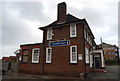
6
The White Hart, Public house, Grays
On the pavement leading to Grays High Street, near Argent Street.
Image: © David Anstiss
Taken: 25 Nov 2012
0.03 miles
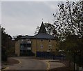
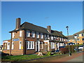
8
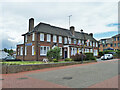
The White Hart, Grays
A grade II listed building, 1938. It replaced an earlier pub.
Image: © Robin Webster
Taken: 19 Jun 2011
0.03 miles
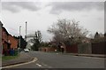
9
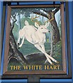
The White Hart, pub sign, Grays
Outside Image
Image: © David Anstiss
Taken: 25 Nov 2012
0.03 miles