IMAGES TAKEN NEAR TO
Vicarage Square, GRAYS, RM17 6JJ
Introduction
This page details the photographs taken nearby to Vicarage Square, RM17 6JJ by members of the Geograph project.
The Geograph project started in 2005 with the aim of publishing, organising and preserving representative images for every square kilometre of Great Britain, Ireland and the Isle of Man.

There are currently over 7.5m images from over14,400 individuals and you can help contribute to the project by visiting https://www.geograph.org.uk
Image Map
Images are licensed for reuse under creativecommons.org/licenses/by-sa/2.0
Notes
- Clicking on the map will re-center to the selected point.
- The higher the marker number, the further away the image location is from the centre of the postcode.
Image Listing (137 Images Found)
Images are licensed for reuse under creativecommons.org/licenses/by-sa/2.0
Image
Details
Distance
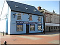
1
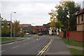
Looking along Argent St towards the old gasworks
Image: © N Chadwick
Taken: 8 Nov 2009
0.03 miles

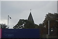
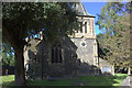
6

St Peter and St Paul's Church, Grays
A view of the tower and south transept.
Image: © Adrian Benn
Taken: 27 Jan 2023
0.06 miles
7
The Mess
Grays Royal British Legion Club.
Image: © Ron Galliers
Taken: 18 Mar 2009
0.06 miles
8

St Peter and St Paul's Church, Grays
As seen from outside the new Thurrock Council offices.
Image: © Adrian Benn
Taken: 27 Jan 2023
0.07 miles
10
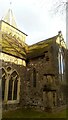
St Peter and St Paul's Church, Grays
An view of the south transept and tower.
Image: © Adrian Benn
Taken: 27 Jan 2023
0.07 miles