IMAGES TAKEN NEAR TO
Cherry Tree Close, GRAYS, RM17 6JA
Introduction
This page details the photographs taken nearby to Cherry Tree Close, RM17 6JA by members of the Geograph project.
The Geograph project started in 2005 with the aim of publishing, organising and preserving representative images for every square kilometre of Great Britain, Ireland and the Isle of Man.

There are currently over 7.5m images from over14,400 individuals and you can help contribute to the project by visiting https://www.geograph.org.uk
Image Map
Images are licensed for reuse under creativecommons.org/licenses/by-sa/2.0
Notes
- Clicking on the map will re-center to the selected point.
- The higher the marker number, the further away the image location is from the centre of the postcode.
Image Listing (60 Images Found)
Images are licensed for reuse under creativecommons.org/licenses/by-sa/2.0
Image
Details
Distance
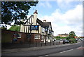
1
Footpath signposted off Clarkbourne Drive
Image: © N Chadwick
Taken: 8 Nov 2009
0.03 miles
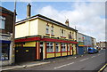
3
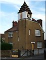
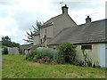
Architectural Whimsy in Little Thurrock
This private house next to the church in Little Thurrock gives no clue as to why the builder felt the need to add a clocktower, some research needed methinks.
Image: © Glyn Baker
Taken: 23 Aug 2005
0.05 miles
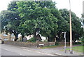
4
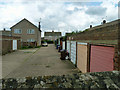
Lock-up garages, Little Thurrock
A view over the churchyard wall. The garage access is from Clarkbourne Drive, beyond the Mini.
Image: © Robin Webster
Taken: 10 Jul 2011
0.06 miles
9
Tin shed, Little Thurrock churchyard
An oddity, with no apparent door. My GPS track suggests I had a look into it, but since I can't remember this, it could not have been very exciting. It looks like a narrow but long WWII Anderson shelter.
Image: © Robin Webster
Taken: 10 Jul 2011
0.08 miles
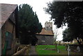
10
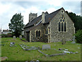
Little Thurrock church
The Church of St. Mary the Virgin is a grade II*(star) listed building, 12th century with 14th century and later alterations.
Image: © Robin Webster
Taken: 10 Jul 2011
0.08 miles