IMAGES TAKEN NEAR TO
Argent Street, GRAYS, RM17 6GD
Introduction
This page details the photographs taken nearby to Argent Street, RM17 6GD by members of the Geograph project.
The Geograph project started in 2005 with the aim of publishing, organising and preserving representative images for every square kilometre of Great Britain, Ireland and the Isle of Man.

There are currently over 7.5m images from over14,400 individuals and you can help contribute to the project by visiting https://www.geograph.org.uk
Image Map
Images are licensed for reuse under creativecommons.org/licenses/by-sa/2.0
Notes
- Clicking on the map will re-center to the selected point.
- The higher the marker number, the further away the image location is from the centre of the postcode.
Image Listing (46 Images Found)
Images are licensed for reuse under creativecommons.org/licenses/by-sa/2.0
Image
Details
Distance
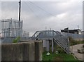
1
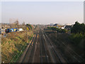
c2c Railway via Grays
Looking east towards Grays from Wouldham Road bridge
Image: © John Winfield
Taken: 19 Dec 2007
0.05 miles
7
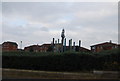
Statue of Britannia, Riverside Gardens, Grays
This statue adorns these newly created gardens along the side of the river Thames.
Image: © N Chadwick
Taken: 8 Nov 2009
0.11 miles
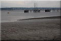
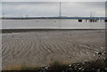
9
Riverside footpath crosses the seawall near Grays Terminal
Image: © N Chadwick
Taken: 8 Nov 2009
0.12 miles
10
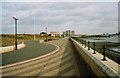
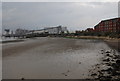
Grays Thamesfront Promenade
Urban renewal begins...
Image: © Michael Parry
Taken: Unknown
0.12 miles