IMAGES TAKEN NEAR TO
Seabrooke Rise, GRAYS, RM17 6DR
Introduction
This page details the photographs taken nearby to Seabrooke Rise, RM17 6DR by members of the Geograph project.
The Geograph project started in 2005 with the aim of publishing, organising and preserving representative images for every square kilometre of Great Britain, Ireland and the Isle of Man.

There are currently over 7.5m images from over14,400 individuals and you can help contribute to the project by visiting https://www.geograph.org.uk
Image Map
Images are licensed for reuse under creativecommons.org/licenses/by-sa/2.0
Notes
- Clicking on the map will re-center to the selected point.
- The higher the marker number, the further away the image location is from the centre of the postcode.
Image Listing (110 Images Found)
Images are licensed for reuse under creativecommons.org/licenses/by-sa/2.0
Image
Details
Distance
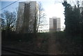
6
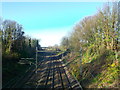
Railway to Grays
As seen from Bridge Road.
This line leads from Tilbury.
Image: © David Anstiss
Taken: 25 Nov 2012
0.11 miles
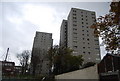
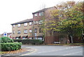
7
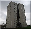
Lionel Oxley House, Grays
One of three New Road tower blocks.
Seen from Bridge Road.
Image: © David Anstiss
Taken: 25 Nov 2012
0.11 miles
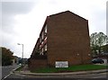
10
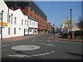
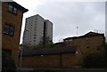
New Road Grays
The main occupant of this street is the Civic Offices of Thurrock Council (the red brick building).
Image: © Ron Galliers
Taken: 18 Mar 2009
0.13 miles