IMAGES TAKEN NEAR TO
Cresthill Avenue, GRAYS, RM17 5UJ
Introduction
This page details the photographs taken nearby to Cresthill Avenue, RM17 5UJ by members of the Geograph project.
The Geograph project started in 2005 with the aim of publishing, organising and preserving representative images for every square kilometre of Great Britain, Ireland and the Isle of Man.

There are currently over 7.5m images from over14,400 individuals and you can help contribute to the project by visiting https://www.geograph.org.uk
Image Map (24 Images)


Getting Data...Please wait
Leaflet Map data © OpenStreetMap
Images are licensed for reuse under creativecommons.org/licenses/by-sa/2.0
Notes
- Clicking on the map will re-center to the selected point.
- The higher the marker number, the further away the image location is from the centre of the postcode.
Image Listing (24 Images Found)
Images are licensed for reuse under creativecommons.org/licenses/by-sa/2.0
Image
Details
Distance
1
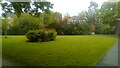
The H. E. Brooks Memorial garden
The garden dedicated to Herbert Edmund Brooks was opened in 1933.
Image: © Adrian Benn
Taken: 6 May 2023
0.10 miles
2
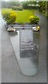
Holocaust Memorial in the H. E. Brooks Memorial Garden
Image: © Adrian Benn
Taken: 6 May 2023
0.10 miles
3
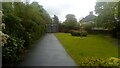
The H.E. Brooks Memorial garden
The garden dedicated to Herbert Edmund Brooks was opened in 1933.
Image: © Adrian Benn
Taken: 6 May 2023
0.11 miles
5
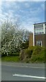
Cherry blossom and telephone exchange
The southern end of the large Telephone Exchange in Bradleigh Avenue, Grays, near the junction with Orsett Road and Bridge Road. Work began on this treasure of a New Elizabethan building c. 1956 and and was completed in 1957. A number of cherry trees, still providing spectacular blossom each spring, were planted at that time.
Image: © Adrian Benn
Taken: 2 May 2023
0.12 miles
6
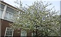
Cherry blossom time
Cherry trees in full bloom at the telephone exchange building in Bradleigh Avenue, Grays. The building was erected in the mid 1950s.
Image: © Adrian Benn
Taken: 24 Apr 2018
0.12 miles
7
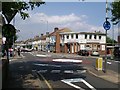
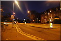
Junction on the A1013
This is the point where the A1013 changes from Palmers Ave to Southend Road. To the left is College Ave and to the right is Chadwell Rd
Image: © Glyn Baker
Taken: 18 Aug 2005
0.13 miles
8
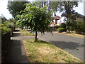
Young tree in Bradleigh Avenue
A young tree thrives in a leafy part of Grays
Image: © Adrian Benn
Taken: 7 Jun 2020
0.13 miles
9
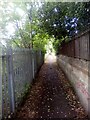
Boundary wall of Palmer's Boys School
The southern boundary wall of the long demolished Palmer's Boys School alongside a path connecting Whitehall Lane and Rectory Road.
Image: © Adrian Benn
Taken: 25 May 2022
0.14 miles
10

A memorial of a former school, Grays
Palmers Boys School was once on this site. It appears that these stones were removed from a building at demolition, and are rather misleading to the uninitiated. The school was actually founded in 1706, but not on this site, but down the hill closer to the town centre. The building here at or very close to this precise site was latterly the Science Block, and was Victorian or Edwardian, certainly earlier than 1934. The other school buildings were newer, and the 1934 date presumably refers to the building of one of them. I don't recall where these stones were. The motto 'Monumentum aere perennis' is certainly the school's, but the coat of arms is not, it is that of Essex. So it seems Essex County Council had the school in hand by then, they certainly did after the war. The school arms were those of the founder, William Palmer, and continue to be used by Palmers College.
Image: © Robin Webster
Taken: 10 Jul 2011
0.14 miles