IMAGES TAKEN NEAR TO
Curling Lane, GRAYS, RM17 5JJ
Introduction
This page details the photographs taken nearby to Curling Lane, RM17 5JJ by members of the Geograph project.
The Geograph project started in 2005 with the aim of publishing, organising and preserving representative images for every square kilometre of Great Britain, Ireland and the Isle of Man.

There are currently over 7.5m images from over14,400 individuals and you can help contribute to the project by visiting https://www.geograph.org.uk
Image Map
Images are licensed for reuse under creativecommons.org/licenses/by-sa/2.0
Notes
- Clicking on the map will re-center to the selected point.
- The higher the marker number, the further away the image location is from the centre of the postcode.
Image Listing (5 Images Found)
Images are licensed for reuse under creativecommons.org/licenses/by-sa/2.0
Image
Details
Distance
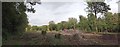
1
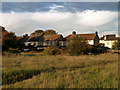
Waste ground, Grays
Grassland stretches across the top ends on the dead-end residential roads that extend north from the A126 London Road. The houses are on Meesons Lane, which extends further than the other roads.
Image: © Robin Webster
Taken: 18 Sep 2011
0.18 miles
2
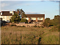
Waste ground, Grays
Grassland stretches across the top ends on the dead-end residential roads that extend north from the A126 London Road. The houses are on Meesons Lane, which extends further than the other roads.
Image: © Robin Webster
Taken: 18 Sep 2011
0.21 miles
3
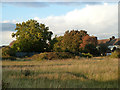
Waste ground, Grays
Grassland stretches across the top ends on the dead-end residential roads that extend north from the A126 London Road. The houses are on Meesons Lane, which extends further than the other roads.
Image: © Robin Webster
Taken: 18 Sep 2011
0.22 miles
5
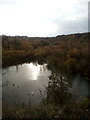
Habitat Restoration in Grays Gorge
Grays Chalk Pit SSSI was being degraded in scientific interest as it was becoming secondary woodland. Tree felling is the first stage of restoring 50% of the floor of the pit to chalk grassland supporting rare plants and invertebrates which was why the SSSI designation was earned.
The site is owned and managed by Essex Wildlife Trust http://www.essexwt.org.uk/.
Image: © Glyn Baker
Taken: 17 Oct 2014
0.25 miles