IMAGES TAKEN NEAR TO
Kiln Way, GRAYS, RM17 5JF
Introduction
This page details the photographs taken nearby to Kiln Way, RM17 5JF by members of the Geograph project.
The Geograph project started in 2005 with the aim of publishing, organising and preserving representative images for every square kilometre of Great Britain, Ireland and the Isle of Man.

There are currently over 7.5m images from over14,400 individuals and you can help contribute to the project by visiting https://www.geograph.org.uk
Image Map
Images are licensed for reuse under creativecommons.org/licenses/by-sa/2.0
Notes
- Clicking on the map will re-center to the selected point.
- The higher the marker number, the further away the image location is from the centre of the postcode.
Image Listing (10 Images Found)
Images are licensed for reuse under creativecommons.org/licenses/by-sa/2.0
Image
Details
Distance
1
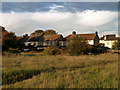
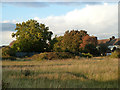
Waste ground, Grays
Grassland stretches across the top ends on the dead-end residential roads that extend north from the A126 London Road. The houses are on Meesons Lane, which extends further than the other roads.
Image: © Robin Webster
Taken: 18 Sep 2011
0.14 miles
2
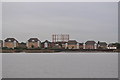
Gas Holder at South Stifford
The South Stiffold gas holder from the river Thames.
Image: © Ashley Dace
Taken: 30 Sep 2010
0.16 miles
3
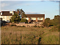
Waste ground, Grays
Grassland stretches across the top ends on the dead-end residential roads that extend north from the A126 London Road. The houses are on Meesons Lane, which extends further than the other roads.
Image: © Robin Webster
Taken: 18 Sep 2011
0.17 miles
4
Waste ground, Grays
Grassland stretches across the top ends on the dead-end residential roads that extend north from the A126 London Road. The houses are on Meesons Lane, which extends further than the other roads.
Image: © Robin Webster
Taken: 18 Sep 2011
0.20 miles
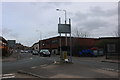
5
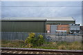
Wharf Road, Grays
The railway line heads to the nearby station on the left side.
Image: © David Howard
Taken: 22 Feb 2020
0.22 miles
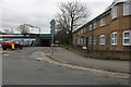
8
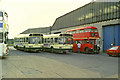
Grays bus garage, 1989
The garage is now demolished and the area a car park. The red RT bus was not allocated here, but just paying a visit on the way back to Canvey Island from a rally in London. There was a time in the past, in London Transport days, when all of the Grays buses were RTs, but green.
Image: © Robin Webster
Taken: 6 Aug 1989
0.24 miles
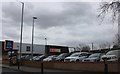
9
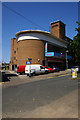
Mecca Bingo hall, Grays
Formerly the Ritz cinema, it was built in the Moderne style to the designs of architect E.Hamilton Parke in 1939, and opened in 1940. Closed in 1976. One of two Grade II (http://list.english-heritage.org.uk/resultsingle.aspx?uid=1384993) or above listed former cinemas in Grays. Bingo operations have served to save redundant cinema buildings, in the same way that public house chains have given new life to post office buildings.
Image: © Jim Osley
Taken: 9 Jul 2013
0.25 miles