IMAGES TAKEN NEAR TO
Lisle Place, GRAYS, RM17 5AP
Introduction
This page details the photographs taken nearby to Lisle Place, RM17 5AP by members of the Geograph project.
The Geograph project started in 2005 with the aim of publishing, organising and preserving representative images for every square kilometre of Great Britain, Ireland and the Isle of Man.

There are currently over 7.5m images from over14,400 individuals and you can help contribute to the project by visiting https://www.geograph.org.uk
Image Map
Images are licensed for reuse under creativecommons.org/licenses/by-sa/2.0
Notes
- Clicking on the map will re-center to the selected point.
- The higher the marker number, the further away the image location is from the centre of the postcode.
Image Listing (9 Images Found)
Images are licensed for reuse under creativecommons.org/licenses/by-sa/2.0
Image
Details
Distance
1
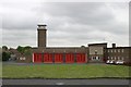
Grays fire station
Grays fire station, Hogg Lane, Grays, Essex, with all the appliance bay doors closed. Compare with Image
Image: © Kevin Hale
Taken: 27 Apr 2009
0.14 miles
2
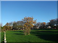
Green near Lodge Road, Chafford Hundred
A cyclepath/footpath from Lenthall Avenue leads past the square green towards Lodge Road.
Image: © David Anstiss
Taken: 25 Nov 2012
0.17 miles
3
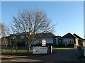
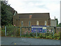
The Grays School,
A Media Arts College is a comprehensive secondary school in Little Thurrock, Grays, Essex.
On Hathaway Road.
It is also used on Sundays, by Kingsway International Christian Centre.
Image: © David Anstiss
Taken: 25 Nov 2012
0.17 miles
4
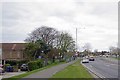
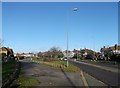
Hathaway Road, Windsor Avenue Junction on Lodge Lane
The Image by Hathaway Rd is to the left
Image: © Glyn Baker
Taken: 31 Mar 2020
0.17 miles
5
Grays Methodist Church
On the corner of Hathaway Road and Lodge Lane, A1306 (formerly A13).
Image: © Robin Webster
Taken: 18 Sep 2011
0.18 miles
6
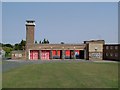
Out On A Shout?
Grays Fire Station there seems to be a distinct lack of appliances I hope no one was in serious trouble.
Image: © Glyn Baker
Taken: 18 Aug 2005
0.18 miles
7
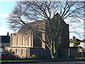
Grays Methodist Church
On the corner of Hathaway Road and Lodge Lane (in front).
Image: © David Anstiss
Taken: 25 Nov 2012
0.18 miles
8
Lodge Lane, Little Thurrock
Lodge Lane leads towards the A1012 (leading towards the A13).
It has houses on both sides with long greens in front of some houses.
Image: © David Anstiss
Taken: 25 Nov 2012
0.21 miles
9
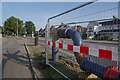
Discharge Point
This where the Image discharges back into the old sewer via a manhole. Anglian Water are renovating the sewer system in Lodge Lane. The pipes are a temporary system to carry the effluent down Lodge Lane to this point. Meanwhile the old sewer can be drained, cleaned out and re-lined to make it water tight once more without having to dig up too much of the road. See https://www.anglianwater.co.uk/hidden-pages/investing-to-protect-homes-and-the-environment-in-grays/ if all goes to plan the over-ground sewer will begin to be dismantled in a few days time.
Image: © Glyn Baker
Taken: 2 Sep 2023
0.23 miles