IMAGES TAKEN NEAR TO
St. Johns Road, GRAYS, RM16 4BF
Introduction
This page details the photographs taken nearby to St. Johns Road, RM16 4BF by members of the Geograph project.
The Geograph project started in 2005 with the aim of publishing, organising and preserving representative images for every square kilometre of Great Britain, Ireland and the Isle of Man.

There are currently over 7.5m images from over14,400 individuals and you can help contribute to the project by visiting https://www.geograph.org.uk
Image Map
Images are licensed for reuse under creativecommons.org/licenses/by-sa/2.0
Notes
- Clicking on the map will re-center to the selected point.
- The higher the marker number, the further away the image location is from the centre of the postcode.
Image Listing (5 Images Found)
Images are licensed for reuse under creativecommons.org/licenses/by-sa/2.0
Image
Details
Distance
1
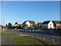
Roundabout on Linford Road (2)
Linford Road leads from Chadwell St Mary towards Linford.
On the right Hill House Drive leads into a small circular close of houses.
Image: © David Anstiss
Taken: 16 Oct 2012
0.09 miles
2
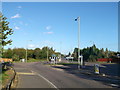
Roundabout on Linford Road
Linford Road leads straight on from Chadwell St Mary to Linford.
Cole Avenue leads left and Sandy Lane leads right.
Image: © David Anstiss
Taken: 16 Oct 2012
0.17 miles
3
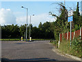
Junction of Sandy Lane and Linford Road
There is a roundabout here, inserted in Linford Road because of new housing on the other side off to the left, rather than Sandy Lane.
Image: © Robin Webster
Taken: 10 Jul 2011
0.17 miles
4
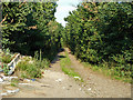
Sandy Lane
A lane marked with green dots on the map over this section. It used to be possible to use this as a through vehicle route from the A126 on the marshes right up to Linford Road. It may still be the case, but it seemed a little rougher than 30-40 years ago, and there was no reason to find out. Having driven down this part from Linford Road, I turned round and went back up it.
Image: © Robin Webster
Taken: 10 Jul 2011
0.19 miles
5
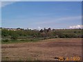
Chadwell from the marshes
Looking north from Biggin Lane towards Chadwell Church.
Image: © John Matthews
Taken: 25 Apr 1999
0.23 miles