IMAGES TAKEN NEAR TO
Colburn Way, GRAYS, RM16 2EG
Introduction
This page details the photographs taken nearby to Colburn Way, RM16 2EG by members of the Geograph project.
The Geograph project started in 2005 with the aim of publishing, organising and preserving representative images for every square kilometre of Great Britain, Ireland and the Isle of Man.

There are currently over 7.5m images from over14,400 individuals and you can help contribute to the project by visiting https://www.geograph.org.uk
Image Map
Images are licensed for reuse under creativecommons.org/licenses/by-sa/2.0
Notes
- Clicking on the map will re-center to the selected point.
- The higher the marker number, the further away the image location is from the centre of the postcode.
Image Listing (17 Images Found)
Images are licensed for reuse under creativecommons.org/licenses/by-sa/2.0
Image
Details
Distance
2
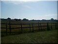
Semblance of the rural in Little Thurrock
Image: © Adrian Benn
Taken: 3 Jun 2022
0.14 miles
3
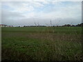
Site of Thurrock Technical College
The site of playing fields attached to Thurrock Technical College (1955-2015). The new housing is on the site of the college itself. The woodland in the distance is known as Terrel's Heath.
Image: © Adrian Benn
Taken: 9 Nov 2020
0.17 miles
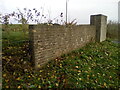
4
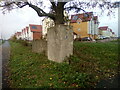
Fragment of Thurrock Technical College Wall
With new housing in the background on the site of Thurrock Technical College, this is a fragment of wall near the former entrance. The tree plays host to mistletoe.
Image: © Adrian Benn
Taken: 9 Nov 2020
0.17 miles
5
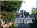
Bridleway crosses King Edward Drive, Little Thurrock
A path from Hangman's Wood, leads over the road towards another path leading past Terrel's Heath and then onwards to Chadwell St Mary.
Image: © David Anstiss
Taken: 25 Nov 2012
0.17 miles
6
The remains of Thurrock Technical College
Part of the wall near the entrance of what was Thurrock Technical College (1955-2015) . Housing has been built on the site.
Image: © Adrian Benn
Taken: 9 Nov 2020
0.17 miles
7
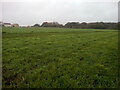
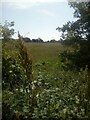
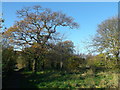
Grassland on former playing fields
Grassland, formerly playing fields attached to the former Thurrock Technical College. This forms part of an important mini greenbelt between Grays and Chadwell-St-Mary
Image: © Adrian Benn
Taken: 9 Nov 2020
0.18 miles
8
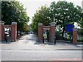
Palmers College
Palmers College was founded in 1706 by William Palmer as a school for the poor to teach the 3R's accounting and Latin. It has been a sixth form college since 1971.
Image: © Glyn Baker
Taken: 18 Aug 2005
0.18 miles
9
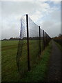
Former playing field
The former playing field for Thurrock Technical College seen through a broken section of the original perimeter fence.
Image: © Adrian Benn
Taken: 9 Nov 2020
0.19 miles
10
Path beside Hangman's Wood
This path is part of a bridleway leading from Chadwell St Mary towards Little Thurrock.
In the wood on the right, are deneholes. Which are underground structures consisting of a number of small chalk caves entered by a vertical shaft. Constructed by the Danes.
Image: © David Anstiss
Taken: 25 Nov 2012
0.21 miles