IMAGES TAKEN NEAR TO
Silverwood Close, GRAYS, RM16 2BU
Introduction
This page details the photographs taken nearby to Silverwood Close, RM16 2BU by members of the Geograph project.
The Geograph project started in 2005 with the aim of publishing, organising and preserving representative images for every square kilometre of Great Britain, Ireland and the Isle of Man.

There are currently over 7.5m images from over14,400 individuals and you can help contribute to the project by visiting https://www.geograph.org.uk
Image Map
Images are licensed for reuse under creativecommons.org/licenses/by-sa/2.0
Notes
- Clicking on the map will re-center to the selected point.
- The higher the marker number, the further away the image location is from the centre of the postcode.
Image Listing (10 Images Found)
Images are licensed for reuse under creativecommons.org/licenses/by-sa/2.0
Image
Details
Distance
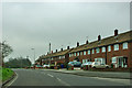
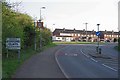
2
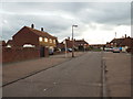
Kingsman Drive, Stifford Clays
Kingsman Drive in Stifford Clays, on the outskirts of Grays. Stifford Clays is a housing estate developed in the 1950s.
Image: © Malc McDonald
Taken: 28 Oct 2017
0.15 miles
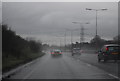
5
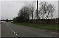
Houses on Stifford Clays Road
The northern edge of the Grays built-up area.
Image: © Robin Webster
Taken: 25 Mar 2012
0.19 miles
7
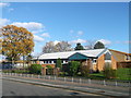
St Peter's Roman Catholic Church, Stifford Clays
On Whitmore Avenue.
Image: © David Anstiss
Taken: 25 Nov 2012
0.22 miles
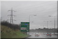
8
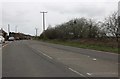
(Covid-19 Exercise 32) Approaching Stifford Clays
A gentle pull up hill into Stifford Clays.
To go to the beginning of this ride visit Image
For the next square see Image
Image: © Glyn Baker
Taken: 24 Mar 2020
0.24 miles
9
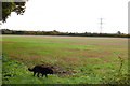
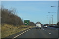
View towards the A13
Looking across a field at Stifford Clays Farm.
Image: © Trevor Harris
Taken: 12 Oct 2013
0.24 miles