IMAGES TAKEN NEAR TO
RM16 1QG
Introduction
This page details the photographs taken nearby to RM16 1QG by members of the Geograph project.
The Geograph project started in 2005 with the aim of publishing, organising and preserving representative images for every square kilometre of Great Britain, Ireland and the Isle of Man.

There are currently over 7.5m images from over14,400 individuals and you can help contribute to the project by visiting https://www.geograph.org.uk
Image Map
Images are licensed for reuse under creativecommons.org/licenses/by-sa/2.0
Notes
- Clicking on the map will re-center to the selected point.
- The higher the marker number, the further away the image location is from the centre of the postcode.
Image Listing (107 Images Found)
Images are licensed for reuse under creativecommons.org/licenses/by-sa/2.0
Image
Details
Distance
1
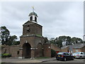
Clock Tower, Purfleet Garrison
The clock tower is one of the few surviving buildings of the Purfleet Garrison.
Image: © PAUL FARMER
Taken: 8 Oct 2011
0.06 miles
2
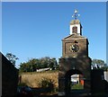
Clock tower and attached walls, Purfleet
Grade II listed clock tower on Mulberry Drive.
See http://www.britishlistedbuildings.co.uk/en-119623-clock-tower-and-attached-walls- for more details about the clock tower.
Image: © David Anstiss
Taken: 7 Nov 2012
0.07 miles
3
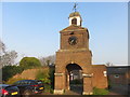
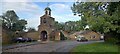
The Garrison Gateway and Clock Tower, Purfleet
The Gateway and attached walls date from c1760s, to the designs of James Gabriel Montresor, Royal Engineer. The eight-day quarter clock was made by London clock maker, Aynsworth Thwaites, of Clerkenwell in 1772.
Image: © Richard Rogerson
Taken: 15 Apr 2019
0.07 miles
4
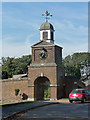
Clock tower, Purfleet
One of few surviving reminders of Purfleet's (almost 200) years as the main location for testing and storing gunpowder. Admittedly, this is a rather tangential reminder, but was built as part of the site, in 1767-68, by James Gabriel Montresor of the Royal Engineers. Grade II listed.
Two other reminders: Image] and Image
Image: © Stephen Richards
Taken: 1 Oct 2011
0.07 miles
6
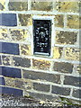
Flush bracket serial number S0875 on Purfleet Primary School
Ordnance Survey flush bracket benchmark described on the Bench Mark Database at http://www.bench-marks.org.uk/bm10926
Image: © Roger Templeman
Taken: 21 Nov 2010
0.08 miles
7
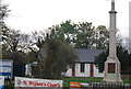
St Stephen's Church & War Memorial, Purfleet
Image: © N Chadwick
Taken: 8 Nov 2009
0.09 miles
8
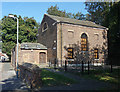
Former proof house, Purfleet
One of few surviving reminders of Purfleet's (almost 200) years as the main location for testing and storing gunpowder. It would have been tested in this modest chapel-like building and, if it reached the requisite standard, then stored in the magazines. It was built c1765 by James Gabriel Montresor of the Royal Engineers. Grade II* listed.
Two other reminders: Image] and Image
Image: © Stephen Richards
Taken: 1 Oct 2011
0.11 miles
9
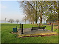
Open Space, Purfleet
A grassed area by the River Thames in urfleet
Image: © Richard Rogerson
Taken: 15 Apr 2019
0.11 miles
10
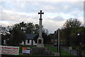
War Memorial, St Stephen's Church, Purfleet
Image: © N Chadwick
Taken: 8 Nov 2009
0.12 miles