IMAGES TAKEN NEAR TO
Mollands Lane, SOUTH OCKENDON, RM15 6RX
Introduction
This page details the photographs taken nearby to Mollands Lane, RM15 6RX by members of the Geograph project.
The Geograph project started in 2005 with the aim of publishing, organising and preserving representative images for every square kilometre of Great Britain, Ireland and the Isle of Man.

There are currently over 7.5m images from over14,400 individuals and you can help contribute to the project by visiting https://www.geograph.org.uk
Image Map
Images are licensed for reuse under creativecommons.org/licenses/by-sa/2.0
Notes
- Clicking on the map will re-center to the selected point.
- The higher the marker number, the further away the image location is from the centre of the postcode.
Image Listing (7 Images Found)
Images are licensed for reuse under creativecommons.org/licenses/by-sa/2.0
Image
Details
Distance
1
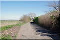
Molands Lane Private Road
Up to this point there is a public right of way, from here on you are technically trespassing.
Image: © Glyn Baker
Taken: 25 Mar 2020
0.03 miles
2

S&J Van Hire
This yard would usually be fairly empty on a working day. Lock-down begins to bite.
Image: © Glyn Baker
Taken: 25 Mar 2020
0.08 miles
3
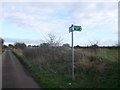
Footpath to Grange Farm
A footpath leads straight on along an access road to Grange Farm, or left along a track towards Buckles Lane.
Image: © David Anstiss
Taken: 25 Nov 2012
0.17 miles
4
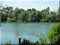
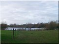
Lake Alexandria, South Ockendon
A flooded gravel pit used for fishing.
Image: © Robin Webster
Taken: 4 Jul 2015
0.18 miles
5
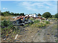
Rubbish on waste ground, South Ockendon
The caravan is abandoned and derelict.
Image: © Robin Webster
Taken: 4 Jul 2015
0.22 miles
6
Alexandria Lake, Grange Farm
As seen from the footpath near the farm.
The lake is a permit only private fishing lake.
Compare with Image
Image: © David Anstiss
Taken: 25 Nov 2012
0.24 miles
7
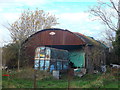
Rusty shed, rusty horsebox
Near Great Mollands Farm.
Image: © David Anstiss
Taken: 25 Nov 2012
0.24 miles