IMAGES TAKEN NEAR TO
Mollands Lane, SOUTH OCKENDON, RM15 6RU
Introduction
This page details the photographs taken nearby to Mollands Lane, RM15 6RU by members of the Geograph project.
The Geograph project started in 2005 with the aim of publishing, organising and preserving representative images for every square kilometre of Great Britain, Ireland and the Isle of Man.

There are currently over 7.5m images from over14,400 individuals and you can help contribute to the project by visiting https://www.geograph.org.uk
Image Map
Images are licensed for reuse under creativecommons.org/licenses/by-sa/2.0
Notes
- Clicking on the map will re-center to the selected point.
- The higher the marker number, the further away the image location is from the centre of the postcode.
Image Listing (14 Images Found)
Images are licensed for reuse under creativecommons.org/licenses/by-sa/2.0
Image
Details
Distance
1
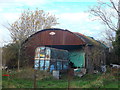
Rusty shed, rusty horsebox
Near Great Mollands Farm.
Image: © David Anstiss
Taken: 25 Nov 2012
0.04 miles
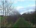
2
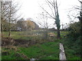
Boardwalk near Great Mollands Farm
A path leads from South Ockendon Hall, beside a field towards Great Mollands Farm on Mollands Lane. It passes over a field ditch and stile.
Image: © David Anstiss
Taken: 25 Nov 2012
0.05 miles
3
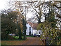
Great Mollands Farm. South Ockendon
Weatherboarded Grade II listed farm on Mollands Lane.
See http://www.britishlistedbuildings.co.uk/en-119755-great-mollands- for more details of the farmhouse.
Image: © David Anstiss
Taken: 25 Nov 2012
0.07 miles
4
Footpath to South Ockendon Hall
A path leads beside a field from Great Mollands Farm towards the Hall on Hall Lane.
Image: © David Anstiss
Taken: 25 Nov 2012
0.10 miles
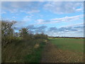
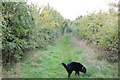
5
Footpath to Great Mollands Farm
This hedge lined path leads from Grange Farm towards another farm.
Image: © David Anstiss
Taken: 25 Nov 2012
0.11 miles
6
Footpath near Grange Farm
Heading north towards South Ockendon Hall.
Image: © Trevor Harris
Taken: 12 Oct 2013
0.11 miles
7
Alexandria Lake, Grange Farm
As seen from the footpath near the farm.
The lake is a permit only private fishing lake.
Compare with Image
Image: © David Anstiss
Taken: 25 Nov 2012
0.12 miles
8
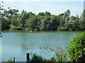
Lake Alexandria, South Ockendon
A flooded gravel pit used for fishing.
Image: © Robin Webster
Taken: 4 Jul 2015
0.13 miles
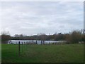
9
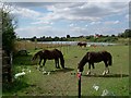
Paddock & Pond
These horses are grazing on Little Mollands Farm. Picture was taken looking west with Grange Farm behind me.
Image: © Glyn Baker
Taken: 21 Aug 2005
0.13 miles
10
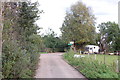
Road to Grange Farm
A public footpath follows the lane towards the farm then turns north at the finger post ahead.
Image: © Trevor Harris
Taken: 12 Oct 2013
0.16 miles