IMAGES TAKEN NEAR TO
Perrys Way, SOUTH OCKENDON, RM15 6DE
Introduction
This page details the photographs taken nearby to Perrys Way, RM15 6DE by members of the Geograph project.
The Geograph project started in 2005 with the aim of publishing, organising and preserving representative images for every square kilometre of Great Britain, Ireland and the Isle of Man.

There are currently over 7.5m images from over14,400 individuals and you can help contribute to the project by visiting https://www.geograph.org.uk
Image Map
Images are licensed for reuse under creativecommons.org/licenses/by-sa/2.0
Notes
- Clicking on the map will re-center to the selected point.
- The higher the marker number, the further away the image location is from the centre of the postcode.
Image Listing (6 Images Found)
Images are licensed for reuse under creativecommons.org/licenses/by-sa/2.0
Image
Details
Distance
1
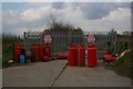
All Gas and Gate
I would have thought empty propane tanks would be too valuable to dump. The showmen mentioned on the sign own much of the land off Buckles Lane and use it for their winter base before travelling the country during the summer months.
Image: © Glyn Baker
Taken: 24 Mar 2008
0.08 miles
2
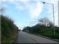
Buckles Lane, South Ockendon
This lane leads towards Grangewaters Water Sports Centre.
Further along the lane are various gypsy caravan sites.
Image: © David Anstiss
Taken: 25 Nov 2012
0.08 miles
3
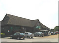
Thurrock Garden Centre, South Ockendon, Essex
Image: © John Winfield
Taken: 29 Jun 2005
0.12 miles
4
Chestnut Tree Farm
Chestnut Tree Farm Garden centre at the junction of South Road and Buckles Lane
Image: © Glyn Baker
Taken: 24 Mar 2008
0.14 miles
5
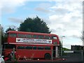
Chestnut Farm Bus
As seen from South Road.
Currently a display for Xmas lights.
Image: © David Anstiss
Taken: 25 Nov 2012
0.16 miles
6
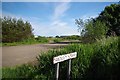
Swaley's Way
Swaley's lane is marked on the map as a right of way, see https://www.thurrock.gov.uk/sites/default/files/assets/documents/rightofway_thurrock_map_201308.pdf for the councils definitive map. However the reinforced concrete footpath sign mysteriously vanished many years ago.
Image: © Glyn Baker
Taken: 25 May 2014
0.23 miles